Route Editor

| Guide | ♦ | 1 Triplog | 0 Topics |
details | drive | permit | forecast | route |
stats |
photos | triplog | topics | location |
| 21 | 1 | 0 |
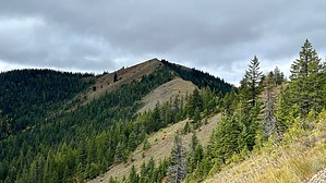
good pointy mountain with rock seating by LindaAnn Hike: Moon Pass is a large intersection of multiple forest roads, with the St Joe Divide Trail heading off to the southwest, between two of the roads. It is not well marked, but it's obvious as a "trail" (really an old road) and not one of the current forest roads. The uphill begins immediately, and the trail is rocky and rutted from frequent dirtbike use.
After about a mile, as you are heading south, the trail starts to descend and meets FS-389. In theory, you could also park at this spot and cut off some of the hiking and elevation gain. At the road, the trail makes a very sharp turn to the right and heads northwest. Looking to your west, you can get your first glimpse of Bad Tom Mountain a few miles away. The peak is pointy, and largely devoid of trees, making it easy to identify. As you head northwest, despite the dense forest, there are plenty of great views to the south and west. The St. Joe Divide Trail generally straddles the divide between the watersheds of the St. Joe (to the south) and Coeur d'Alene (to the north) Rivers. The trail gradually drops down towards Slate Creek Saddle. Shortly before reaching the saddle, the trail reaches FS-985, turns left, and follows the road down to the saddle. Again, multiple forest roads converge at the saddle, as you are heading west, take the trail to the left and begin heading uphill again. The climb is a little steeper than what you just descended as you head up towards Placer Peak. The trail skirts just to the south of the true summit as you continue west. Once past Placer Peak, the trail condition improves as you once again head back downhill to the next saddle. Views to the north finally open up through this section. At the saddle, Bad Tom Mountain looms directly in front of you. The trail climbs uphill along the southeast slope of the peak (there is a use-trail that goes straight up the ridge, but the trail is much easier), then makes a very distinct right turn and heads straight north, steeply up to the summit. The summit is broad and flat, with great views in all directions. There is an outcropping of rocks at the north edge, allowing for a place to sit and rest. To return, head south back off the summit, then left to head east back towards Placer Peak. The only significant route finding on the return is at Slate Creek Saddle. Heading east, take the left fork, heading uphill for a short distance. Look for the trail to veer off to the right, with the only marking being a metal diamond with a '16' on it nailed to a tree. After that, you climb back around the south side of Moon Peak before finally descending the final mile to Moon Pass. Check out the Official Route and Triplog. Leave No Trace and +Add a Triplog after your hike to support this local community. | |||||||||||||||||||||||||||||||||||||||||||||||||||||||||||||||||||||||||||||||||||||