Route Editor

| Guide | ♦ | 5 Triplogs | 0 Topics |
details | drive | no permit | forecast | route |
stats |
photos | triplogs | topics | location |
| 87 | 5 | 0 |
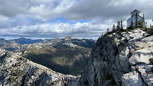
meaty buffet of views by LindaAnn Hike: From the parking area, there is a boulder on the east side of the road with a metal sign for Lookout Lake attached to it. The trail starts just to the left of the boulder and immediately heads uphill through dense vegetation. The trail is narrow, but distinct, as it winds through the trees. After a little over half a mile, the trail levels off as it approaches the west side of Lookout Lake. The small lake sits in a cirque, surrounded by granite walls, as you walk south along the west side of the lake. There are a few trails that lead down to the lake shore, and they are worth checking out. The Lookout Mountain cabin can be seen, perched high above the lake, towards the southeast. There are a few campsites near the southwest side of the lake. Use proper food storage practices, given the wildlife in the area.
The trail is rocky, but in generally okay condition as you head uphill. Views of Priest Lake begin to appear to the south. As you climb higher, more of the Selkirk Mountains come into view, and the Selkirk Crest is visible to the east. The trees get shorter as you ascend, and the views get better. Once the trail turns to the north, it still gets steeper, and rockier. About three hundred vertical feet below the summit, the trail turns to an old road. While steep, you know you are getting close to the top at this point. Approaching the summit, an old outhouse comes into view ahead of you, then the lookout tower. At the top, the old lookout cabin is perched on the very edge of the rocks, just beyond the tower. Views to the north are dramatic, with Lookout Lake now visible below you. Heading east to the cabin brings even more views to the east. There's a marker on the cabin door with a brief history of the cabin--built in 1929, the last of its kind still standing--and you can peek in the door, making sure to relatch it when done. The tower is in poor condition, and signs warn you to stay off of it. Make sure to walk around the summit to get the views in all directions. Once done, retrace your steps back downhill. The old road has some loose rock, but the footing gets better as you descend back onto the trail. Once back to the somewhat confusing turn back at the forest road, you have two choices: retrace your steps back to the parking area via Lookout Lake, or head down from the road for a faster route to your vehicle. I'd suggest the faster route if you don't mind some road walking since the views are better. At that turn, go south and cross the road, picking up the trail immediately on the other side. The trail continues south for a short distance, which feels like the wrong direction, but it will turn sharp right and head northwest. Some maps seem to have this trail labeled as the "Pacific Northwest Trail". Follow the trail as it crosses Lucky Creek (there is a trail that turns right and goes up to a small lake which is the headwaters of the creek) and then it reaches another forest road. Turn right and follow the forest road west, then north all the way back to your vehicle. The walking is flat and easy on the road, with great views to the west. Check out the Official Route and Triplogs. Leave No Trace and +Add a Triplog after your hike to support this local community. | |||||||||||||||||||||||||||||||||||||||||||||||||||||||||||||||||||||||||||||||||||||