username
X
password
register
for free!
help


Hoapili Trail to Hanomanioa Light, HI

Guide 1 Triplog  0 Topics
  4 of 5  
Fav
Wish
0
HI > Maui
details
drive
no permit
forecast
route  
stats
photos
triplog
topics
location
14 1 0
HAZ reminds you to respect the ruins. Please read the Archaeological Resources Protection Act of 1979 & Ruins Etiquette
Statistics
tap row or icons for details
Difficulty 1 of 5
Route Finding 1 of 5
Distance Round Trip 3.78 miles
Trailhead Elevation 9 feet
Elevation Gain 1 feet
Accumulated Gain 264 feet
Avg Time Round Trip 2.5 hours
Kokopelli Seeds 5.1
 Interest Ruins & Historic
unreported if dogs are allowed
editedit > ops > dogs to adjust
feature photo
Photos Viewed All MineFollowing
Inaugural Calculation on Button Tap!
14  2023-10-23 The_Eagle
Author
author avatar Guides 41
Routes 1,626
Photos 14,983
Trips 2,760 map ( 18,597 miles )
Age 69 Male Gender
Location Far NE Phoenix, Az
Historical Weather
Trailhead Forecast
Radar Map
Expand Map
Preferred Jan, Jan, Jan, Jan → 7 AM
Sun  6:11am - 6:38pm
Official Route & 1 Rt
 
0 Alternative


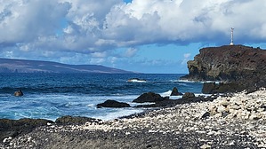
Volcanic Goats and Crashing Waves
by The_Eagle

 
The Hoapili Trail to Hanomanioa Light is on Maui's southern coast, and is an out-and-back hike showing the island's history, volcanic oceanfront ruggedness, and an intriguing inhabitant: its feral goat population.


On the drive in you start noticing the feral goats. We called them volcanic goats because they blended in so well with the volcanic rock. These are descendants of domestic goats brought to Maui by early settlers. These goats have adapted to their harsh environment, navigating the rocky landscape with agility.
remove free decal offer
The Hoapili Trail runs on and then next to the much longer ancient King's Highway footpath. It connected many coastal villages, emphasizing its historical significance to Hawaii.

As you hike along the rugged Hoapili Trail, you'll notice the stark, arid terrain characteristics of Maui's southern coast. The coast has been shaped by centuries of volcanic eruptions. If you are hiking early enough, looking to the north are the islands' tallest peaks in the Haleakala National Park can be seen. These rise more than 10,000'. Hiking later in the day, they will more than likely be obscured in cloud cover.

At the trail's turnaround is the historic Hanomanioa Light. It was built in the late 19th century to guide ships through the dangerous southern coast. Views from this light offer stunning panoramic views of the vast Pacific Ocean.

There is little shade and with all the rock, it can be warm. There are a few places along the way that allow you to take a dip in the ocean to cool off.

2023-11-02 The_Eagle


    Check out the Official Route and Triplog.
    Leave No Trace and +Add a Triplog after your hike to support this local community.
    WARNING! Hiking and outdoor related sports can be dangerous. Be responsible and prepare for the trip. Study the area you are entering and plan accordingly. Dress for the current and unexpected weather changes. Take plenty of water. Never go alone. Make an itinerary with your plan(s), route(s), destination(s) and expected return time. Give your itinerary to trusted family and/or friends.

     Permit $$
    None


     Directions
    or
     Road
    Paved - Car Okay

    To hike
    Take Makna road, south out of Makena (south of Wailea) to the end of the road. There is some parking here. More parking will be to the right in a lot closer to the TH that can handle a dozen or so cars.
    page created by The_Eagle on Nov 02 2023 9:51 am
     90+° 8am - 6pm kills
    helpcorrectionissue

    end of page marker