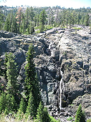
History: The Lakes Basin Recreation Area was created somewhere about 180,000 years ago when glaciers covered the land. Annual melting and refreezing created frost wedging, cracking and loosening of rock and as the glaciers moved they carried the loose rock further carving the landscape. This process eventually created the post glacial waterfall called Frazier.
Overview: This area gets an average of ten feet of snow a season which lasts well into June. The snowmelt flows from the Lakes Basin into Frazier Creek on its descent more than 2,000 feet to the Middle Fork of the Feather River. Frazier Falls overall is a cascade of 248 feet with a waterfall of 176 feet making it one of the highest waterfalls in California.
Hike: There is sufficient room at the trailhead for several cars. There are picnic tables and a restroom. The trail winds thru the forest among huge granite boulders placed by retreating glaciers long ago. There are plenty of grasshoppers and squirrels all looking for a handout. At about 1/4 mile there is a wooden bridge over Frazier Creek. The trail continues straight but taking a left here and hugging the left bank of the creek will bring you out to the sheer drop off which is Frazier Falls in about 200 yards. Great care should be exercised here as there are no barriers and the boulders can be slippery. Returning to the trail take it to the left and continue around to a nice overlook opposite the falls which is perfect for photographing them. This area is well protected by barriers due to the steep cliffs. The water generally flows year round but the strongest flows are in the spring. Return the way you came.
When hiking several trails on a single "hike", log it with a generic name that describes the hike. Then link the trails traveled, check out the example.
WARNING! Hiking and outdoor related sports can be dangerous. Be responsible and prepare for the trip. Study the area you are entering and plan accordingly. Dress for the current and unexpected weather changes. Take plenty of water. Never go alone. Make an itinerary with your plan(s), route(s), destination(s) and expected return time. Give your itinerary to trusted family and/or friends.
Permit $$
None
Directions
Road
FR / Dirt Road / Gravel - Car Okay
To hike 1.5 miles south of Graeagle on Highway 89. Turn left (west) on Gold Lake Hwy (Road 24), signed for Gold Lake. Drive 1.7 miles south to the signed turnoff for Frazier Falls. Turn left and drive 4.3 miles to the trailhead parking lot.
 Route Editor


