Red Mountain, White Snow, Blue Sky... a patriotic mountain by Mike_W
Overview
Red Mountain, at an elevation of 7,361 feet, is a small mountain just south of the town of Manitou Springs, Colorado. This hike has a great trail and it's easily possible to finish this hike in under 2 hours. There are some nice views at the top.
Hike
I drove by the trailhead and did not see any parking what-so-ever but something about not blocking a so-called fire access. Then, I saw a private road heading higher up the slope which I could not take. In the surrounding area, there were signs saying resident parking all over. I asked some locals where to park and one person suggested parking in the alleyway south of the Manitou Elementary School. In this area, I didn't see any resident stickers, so I thought it would be OK to leave my car here for a few hours.
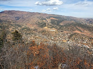
From here I walked south on Pawnee Ave (going uphill) for 0.4 miles until I reached the Paul Intemann trailhead. I turned right taking the trail. There was a good sign and map at the trailhead. The trail was relatively flat and easy to follow. After about 0.6 miles, I reached a junction with the Red Mountain trail. I turned left here and the well-maintained trail started to climb. There were several switchbacks and the hike was through a forested area of pines. Eventually, I made it to the top and there were some great views of Manitou Springs and some nearby hills that were slightly lower in elevation. There was a red and white striped pole at the summit. I did not see a registry. Looking west I could see some of the snow-covered peaks near Pikes Peak, but I was pretty sure I could not see the peak from here. I followed the same route down to where I parked.
WARNING! Hiking and outdoor related sports can be dangerous. Be responsible and prepare for the trip. Study the area you are entering and plan accordingly. Dress for the current and unexpected weather changes. Take plenty of water. Never go alone. Make an itinerary with your plan(s), route(s), destination(s) and expected return time. Give your itinerary to trusted family and/or friends.
Permit $$
Information is listed below
Directions
Road
Paved - Car Okay
To hike From the center of Manitou Springs, CO, travel west on Manitou Ave and travel for 500 feet until you reach Pawnee Ave and turn left going south. Continue on Pawnee Ave for 0.1 miles. You will see the Manitou Elementary School to your right. Pass the school and turn right down the alley behind the school. I was told a lot of teachers park here and some locals and I don't believe a Manitou resident pass/sticker is needed. I parked here twice for several hours and was not ticketed. The town of Manitou needs to add a few spaces of free parking for tourists/hikers. Having to pay for parking near a walking trailhead is a bit ridiculous in my opinion.
 Route Editor