username
X
password
register
for free!
help


Peak 2654 - Maricopa Mountains, AZ

Guide 2 Triplogs  0 Topics
  2.5 of 5  
Fav
Wish
0
details
drive
no permit
forecast
route  
stats
photos
triplogs
topics
location
36 2 0
Statistics
tap row or icons for details
Difficulty 3.5 of 5
Route Finding 3 of 5
Distance Round Trip 6.5 miles
Trailhead Elevation 1,453 feet
Elevation Gain 1,199 feet
Accumulated Gain 1,325 feet
Avg Time Round Trip 4.5 hours
Kokopelli Seeds 13.13
 Interest Off-Trail Hiking, Seasonal Waterfall, Seasonal Creek & Peak
 Backpack Possible - Not Popular
unreported if dogs are allowed
editedit > ops > dogs to adjust
feature photo
Photos Viewed All MineFollowing
1  2024-01-28 pseudalpine
35  2023-12-06 Mike_W
Author
author avatar Guides 104
Routes 256
Photos 16,118
Trips 528 map ( 2,863 miles )
Age 53 Male Gender
Location Tucson, AZ
Historical Weather
Trailhead Forecast
Radar Map
Expand Map
Preferred Nov, Dec, Jan, Feb → 9 AM
Seasons   Autumn to Spring
Sun  6:07am - 6:50pm
Official Route
 
0 Alternative


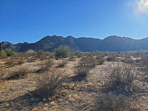
high viewpoint for Southern Pacific railway
by Mike_W

 
Overview
Peak 2654, in the South Maricopa Mountains, has an elevation of 2654 feet. There is no trail and this hike involves some light rock climbing, but nothing that would require ropes if you choose your route wisely. There's not much brush, except for in some areas of the upper canyon. Your main obstacles will be rocks and boulders!


Hike
If you parked near where I parked, walk South toward the railway line. There should be a break in the fence somewhere in this area. You'll need to cross the tracks and then cross one more fence. Start heading South through the desert. You'll notice that it's easy hiking here. You won't see a lot of cacti, just a few scattered saguaros, a lot of creosote, some ocotillo, and palo verde trees near the washes. I was wondering what happened to the prickly pear and the cholla. No complaints but this area seems to be missing all of that.
remove free decal offer
Check my published route and enter the canyon at that location. You will see some huge boulders in the lower part of the canyon. You should be able to walk around them to the left or right. If you're adventurous like me, you might choose to hike/climb through and over the boulders. One past the boulders, you can stay in the canyon for a while. It should be sandy here with not a lot of brush, but you will need to zig-zag around a lot of rocks. When the canyon starts getting messy, climb up the left side and you will see a clearer way to go. Sometimes there are huge boulders to climb over/around and sometimes you will be on dirt. Way up high, you will see a notch in the canyon. You will watch to travel in that general direction. Pass through the notch if you are inside the canyon, or climb around it. Use whichever route is easier for you. After passing this area, you should have a clear look at the peak and the path leading up to it. I approached the peak from the northeast side but there was more than one good way to go.

At the summit, I found a registry that had not been signed since September 2020. This peak doesn't get too many visitors because it is so remote. If you look to the south, you should see I-8 which is 5 or 6 miles away. Because you're quite high up, the highway is pretty easy to see. Looking east and slightly south you should see the Maricopa Mountains high point. Looking north you will see Maricopa Road and the railway where you started. If you're lucky, you'll see a train go by from the summit and curve around some of the mountains in the distance.

On the way back you can take the same route back or follow my route which goes a slightly different way. I found the canyon to be an interesting place, full of huge boulders and unusual rock formations.

2023-12-07 Mike_W


    Check out the Official Route and Triplogs.
    Leave No Trace and +Add a Triplog after your hike to support this local community.
    WARNING! Hiking and outdoor related sports can be dangerous. Be responsible and prepare for the trip. Study the area you are entering and plan accordingly. Dress for the current and unexpected weather changes. Take plenty of water. Never go alone. Make an itinerary with your plan(s), route(s), destination(s) and expected return time. Give your itinerary to trusted family and/or friends.

     Permit $$
    None


     Directions
    or
     Road
    Paved - Car Okay

    To hike
    From the center of Gila Bend, set your odometer to 0. Take 85 N to W Maricopa Rd. Continue onto AZ-238 E. After you have traveled a total of 16.2 miles, look for a dirt road on the south side of the road. Park here. I could not find any short route that crossed the railroad tracks. You'll need to walk south and cross over the tracks. See my route for more info. I followed a road simply to see where it went. I thought I might find a road going south but I did not. It's easy to walk through the open desert in this area. You can park at/near this GPS location: 32.99704, -112.454799
    page created by Mike_W on Dec 07 2023 11:10 pm
     90+° 8am - 6pm kills
    helpcorrectionissue

    end of page marker