Route Editor

| Guide | ♦ | 1 Triplog | 0 Topics |
details | drive | permit | forecast | route |
stats |
photos | triplog | topics | location |
| 0 | 1 | 0 |
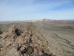
Party Peak!! by Jim   The Tule Mountains are either a small range south of the Cabeza Mountains, or a sub-range of the larger Cabeza Mountains. While not as tall as surrounding ranges, they are still spectacular granite mountains (or hills) and a worthwhile stop while driving El Camino Del Diablo, or if just visiting the Cabeza Prieta National Wildlife Refuge. If you want to see Elephant Trees, this range has an abundance of them. I can not recall there being so many in the local ranges as there are here. Most are smaller shrubs, but they're here. The Tule Mountains are either a small range south of the Cabeza Mountains, or a sub-range of the larger Cabeza Mountains. While not as tall as surrounding ranges, they are still spectacular granite mountains (or hills) and a worthwhile stop while driving El Camino Del Diablo, or if just visiting the Cabeza Prieta National Wildlife Refuge. If you want to see Elephant Trees, this range has an abundance of them. I can not recall there being so many in the local ranges as there are here. Most are smaller shrubs, but they're here.Peak 1999 is the high point of the range. It offers excellent local views, and probably due to reliable water in nearby tanks in the dry times, bighorn sheep seem to enjoy the summit and ridges leading to it.
Once on the summit ridge, head north towards the top. It is possible to add some class 3 scrambling to the trip at the top by going directly up the south face to the summit, but you can keep things class 2 by dropping down to the west and coming up from the west side, as I descended. This is all in the last 50 or so vertical feet. Most of the ascent hike is just a steep hike. Descend the way you came. Rock quality here is typically good. The rocky debris-strewn slopes can slide, so use caution. I found far less cholla than I recall from places like Buck Mountain, so there is that positive! After the peak, you might want to check out Tule Tank, which is one of the few natural water sources along the historic El Camino Del Diablo. If you have more time, hike over the hills above the Tank, or hike the jeep trail around the east side of the range, and visit Buckhorn Tank. These water sources are important for local wildlife and critical in the hot dry months. Enjoy your time out here in the desert! Check out the Official Route and Triplog. Leave No Trace and +Add a Triplog after your hike to support this local community. | |||||||||||||||||||||||||||||||||||||||||||||||||||||||||||||||||||||||||||||||||||||