username
X
password
register
for free!
help
  🔥

Campaign Crystalline / Shark Fin, AZ

Guide 6 Triplogs  0 Topics
  2 of 5  
Fav
Wish
0
details
drive
no permit
forecast
🔥
route  
stats
photos
triplogs
topics
location
8 6 0
Warning! Technical climbing skills required. Risks include serious injury to death.  Risks are not eliminated by skill.
Historical Weather
Trailhead Forecast
Radar Map
Expand Map
Preferred Dec, Jan, Feb, Mar → 7 AM
Seasons   Autumn to Spring
Sun  6:01am - 6:45pm
Official Route
 
1 Alternative
 
Historic Fire Perimeteracres
🔥 2019 Woodbury Fire123.8k


feature photo
Photos Viewed All MineFollowing
2  2024-02-01
Shark Teeth and Fin plus the Billet
pseudalpine
5  2022-02-06
Black Mountain - Eastern Superstition Mtns
pseudalpine
2  2016-01-22 pseudalpine
1  2000-02-12 pseudalpine
Climb Section

+Add your Photos & Triplogs!
You can add routes when posting a triplog
L>R Routes Rated Difficulty Trips
Flying HatT 5.6 55 ft1
Login for beta
Fat GapT 5.8 55 ft1
Login for beta
Rappel RouteT 5.6 55 ft1
Login for beta
Gale Force or var. Exit RightT 5.10a 110 ft1
Login for beta
Nugatory 1
Login for beta
+Add > Triplog to share climbs & add routes
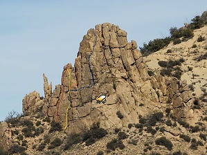
At least they weren't Africanized, yet!
by pseudalpine

S_1864.jpg?V=0.jpg
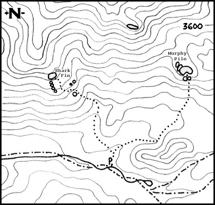
This southwest-facing, 110' granite wall can easily be seen by looking east from the fire ring at the Sycamore camp. There may be a few potential routes on the right side of the wall, but only if you enjoy climbing past some very large honeycombs and on loose rock. There are four and a third completed routes on this formation.


You may be wondering, why a third? Because my first ground up solo ascent at Campaign Crystalline was quickly aborted after hand-drilling a first bolt on lead hooks and then gaining the main ledge above, only to discover the biggest wild bee colony that I've ever encountered in my life! Luckily, they were unbothered by me, but about a two decades later assessment determined that the colony was still alive and well. I have not checked their activity recently and only included this crag in a historical context.
remove free decal offer
WARNING
If one chooses to climb here, I'd make sure the colony is abandoned, inactive, or do it on an extremely cold and windy day (as we did the first free ascents in February 2000).

The official route from the Sycamore camp walks the road north to the next steep wash that originates from the saddle south of the Shark Fin or head northeast, crossing a nearly impenetrable acacia bramble, eventually dropping into the same previously mentioned wash. Continue up the wash, bearing left (east), exiting onto the talus before or at the first fork. The talus ascent is steep, but several faint paths lead to the crag.

2024-01-07 pseudalpine
  • Shark Fin & Murphy Pile
    guide related
    Shark Fin & Murphy Pile


Check out the Official Route and Triplogs.
Leave No Trace and +Add a Triplog after your climb trip to support this local community.
WARNING! Hiking and outdoor related sports can be dangerous. Be responsible and prepare for the trip. Study the area you are entering and plan accordingly. Dress for the current and unexpected weather changes. Take plenty of water. Never go alone. Make an itinerary with your plan(s), route(s), destination(s) and expected return time. Give your itinerary to trusted family and/or friends.

 Permit $$
no fees or permits reported

if incorrect tell us about it


 Directions
or
 Road
Paved - Car Okay

To Upper Horrell Trailhead
From SR 188 turn off onto 449 (also called J-B) just past milepost 235 Follow 449 about two miles to the junction with Cross P Ranch. FR449A is located through the white fence to the left of the Ranch. FR449A is said to be possibly used by high clearance vehicles. I wouldn't recommend. There are some deep sections of sand as well as a couple creek crossings. This is no place to get stuck, no cell phone signal and a long day hike back to SR88. Follow FR449A about six miles to the Upper Horrell(Campaign) Trailhead parking. Along FR449A notice the awesome slot canyon passed along the way.

From PHX (I-10 & AZ-51) 112 mi - about 2 hours 25 mins
From TUC (Jct 1-10 & Grant) 154 mi - about 3 hours 28 mins
From FLG (Jct I-17 & I-40) 178 mi - about 4 hours 18 mins
page created by pseudalpine on Dec 31 2023 4:02 pm
 90+° 8am - 6pm kills
helpcorrectionissue

end of page marker