Route Editor

| Guide | ♦ | 1 Triplog | 0 Topics |
details | drive | no permit | forecast | route |
stats |
photos | triplog | topics | location |
| 37 | 1 | 0 |
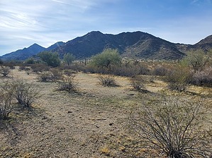
The OTHER "Sheep Mountain", West by Mike_W  Overview OverviewThis off-trail hike is part of the Sonoran Desert National Monument about 15 miles north of Gila Bend and is also part of the North Maricopa Mountains. Some steep rocky areas will probably involve using your hands higher up. Camping There's a campsite called Margies Cove West Campground which is within a few miles of a good place to start this hike. If you plan on staying overnight, this is a good place to stay. There's also a trailhead called Margies Cove at this location, which is a separate trail from this guide and would be nice to pair with Sheep Mountain West.
Looking to the south and slightly west you'll see two high points. It looks like the left-most high point (Peak 2180, at 2180 feet elevation) is the summit, but it is not. The peak on the right side is 2 feet higher at 2182 feet elevation, but it looks lower because it is slightly further away. There are a few ways to hike this peak and you may want to summit 2180 also, although we decided to skip it. If you want to climb 2180, follow the eastern side of my GPS loop entering the canyon. There are a few rocky areas but the rocks were mostly stable. Watch out for a few wobbly rocks along the way. Keep climbing up and after hiking about 0.75 miles you can curve to the west and head toward the ridgeline. Once on the ridgeline, you'll have some rocky areas to climb over, or around. When you get higher up, you will reach a small saddle. Peak 2180 will be right in front of you, about 100 vertical feet up. At this point, you should have traveled around 1.15 miles. If you decide to summit Peak 2180 you can continue climbing to the south. If you are mainly interested in the "official" high point at 2182, you will hike 0.4 miles to the west, aiming for the low saddle that is east of Peak 2182. Once you reach the saddle, you will walk along a flat area that turns and heads towards the peak. From here you can start going up, right of a rocky canyon. It gets pretty steep here so you should plan on zig-zagging where the slope looks better. I saw at least 3 cairns in the upper section and followed those to the top ridgeline. From here, continue north to the high point. The registry was a bit hard to find but you'll find it under a rock pile at the very top. I added a few rocks to highlight the position better. The plastic jar was in bad shape, and some pages were hardly readable. I replaced the plastic jar with a glass jar and hopefully that will preserve the registry better. On the way down, follow the western part of my GPS route which basically follows a ridgeline down. This seemed like an easier way to go and could be followed for both directions of the hike. Check out the Official Route and Triplog. Leave No Trace and +Add a Triplog after your hike to support this local community. | |||||||||||||||||||||||||||||||||||||||||||||||||||||||||||||||||||||||||||||||||||||||||||||||||||