username
X
password
register
for free!
help


Gila Valley Lookout, AZ

Guide 40 Triplogs  0 Topics
  2.8 of 5  
Fav
Wish
0
details
drive
no permit
forecast
route  
stats
photos
triplogs
topics
location
27 40 0
Statistics
tap row or icons for details
Difficulty 0.5 of 5
Route Finding 1 of 5
Distance One Way 0.42 miles
Trailhead Elevation 2,621 feet
Elevation Gain -189 feet
Accumulated Gain 3 feet
Avg Time One Way 20 minutes
Kokopelli Seeds 0.43
feature photo
Photos Viewed All MineFollowing
Inaugural Calculation on Button Tap!
2  2025-08-24
Dobbins & Gila Lookouts
johnlp
2  2025-06-30
Gila Harvester
trekkin_gecko
3  2025-06-30
Gila Harvester
johnlp
1  2025-03-05
Harvester Gila
johnlp
7  2025-02-05
Gila Lookout from Warpaint
trekkin_gecko
7  2025-02-05
Corona Plus
LindaAnn
9  2025-02-05
Gila Lookout from Warpaint
chumley
4  2025-01-28
Corona Loop
johnlp
Page 1,  2,  3
Author
author avatar Guides 69
Routes 37
Photos 3,010
Trips 2,387 map ( 14,004 miles )
Age 55 Male Gender
Location Phoenix,Az
Historical Weather
Trailhead Forecast
Radar Map
Expand Map
Preferred Jan, Dec, Feb, Nov → 7 AM
Sun  6:04am - 6:50pm
Official Route & 2 Rts
 
15 Alternative


National Connection
by mt98dew

 
Overview
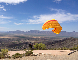
The Gila Valley Lookout is the newest trail to the South Mountain Trail system and is one of over 40 trails available in the park. This is a short trail that connects the Gila Valley Lookout to the National Trail. There are a couple of shade awnings and parking for over 30 cars at this trailhead. The amount of parking makes this an ideal starting point for someone who wants to hike the National from the middle. At the time of this writing, there are no benches, bathrooms, or water available at this site.


Hike
The Gila Valley Lookout (GVL) Trail is more of a connector trail than a destination trail. The trail is only 0.46 miles long and goes from the Lookout down to the National Trail. The trail for the most part is a very smooth single track, though it is a little rocky near the TH. It is an odd trail, in the sense, that one is starting at the most scenic spot and hikes down and away from the best views. The trail takes off from the east side of the parking area and switchbacks down about 60 feet to a lower-level ridge.
remove free decal offer
From here, (and the parking area) you get great, unrestricted views to the south and the east. The trail drops from this ridge another 160 feet down the northern slope. This is a steady decline with no switchbacks. Once at the bottom, the trail crosses a small wash and then crosses South TV Rd before connecting to the National. This juncture is well signed and there are no user tracks that connect to the GVL so there should be little confusion with this trail. From here, the choices are limited. One can return the way they came for just under a 1-mile hike. Or, one can use this trail as a starting point, and take the National Trail east towards Holbert Trail and Buena Vista Lookout or west toward the Telegraph Trail and Goat Hill.

Note
At the time of this writing, the TH is still under construction, so there may be more amenities coming to this site. Also, because the TH is under construction, the only way to access this trail is from the National Trail. Currently, the easiest way to access the Gila Valley Lookout would be via the Buena Vista Lookout which involves a 1.2-mile hike along the National.

2024-01-04 mt98dew
  • 2022 South Mountain Park
    area related
    2022 South Mountain Park


Check out the Official Route and Triplogs.
Leave No Trace and +Add a Triplog after your hike to support this local community.

One-Way Notice
This hike is listed as One-Way.

When hiking several trails on a single "hike", log it with a generic name that describes the hike. Then link the trails traveled, check out the example.
WARNING! Hiking and outdoor related sports can be dangerous. Be responsible and prepare for the trip. Study the area you are entering and plan accordingly. Dress for the current and unexpected weather changes. Take plenty of water. Never go alone. Make an itinerary with your plan(s), route(s), destination(s) and expected return time. Give your itinerary to trusted family and/or friends.

 Permit $$
None


 Directions
or
 Road
Paved - Car Okay

To hike
From Phoenix take Central to the park entry. From the entry point take San Juan Rd 1 mile and then make a left on Summit Rd and follow Summit Rd up the mountain. At about 4.8 miles make a right onto N. Buena Vista Rd. At around 5.3 miles make a right onto South TV Rd and the TH will be at the end of the road.
page created by mt98dew on Jan 04 2024 4:49 am
 90+° 8am - 6pm kills
helpcorrectionissue

end of page marker