Route Editor

| Guide | ♦ | 1 Triplog | 0 Topics |
details | drive | permit | forecast | route |
stats |
photos | triplog | topics | location |
| 0 | 1 | 0 |
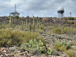
mountain and child reunion by DixieFlyer  Overview OverviewChilds Mountain is north of the town of Ajo and is in the extreme eastern section of the Cabeza Prieta National Wildlife Refuge. The elevation of Childs Mountain is 2,880 feet and it has prominence of 1,240 feet. Etymology Childs Mountain is named for Tom Childs(1839-1902), who owned a ranch and a mine near Ajo in the late 1800's.
Sources: Arizona's Names (X Marks the Place), by Byrd Howell Granger and Arizona Place Names, by Will C. Barnes History Childs Mountain is the location of the Ajo Air Force Station (AFS) which was built in the Cold War days in response to the Soviet Union’s development of high-altitude, long-range bombers capable of delivering nuclear payloads to targets on American soil. The AFS became active in 1958 and was one of 142 radar stations built in the United States and Canada to detect and monitor a potential Soviet incursion into North American airspace. At any given time there were 100 military personnel at the Ajo AFS, and several structures were built: dormitories, an administration building, an officer’s club, a mess hall, a recreation hall, a base exchange, a vehicle maintenance shop, a central power plant, and recreational facilities including a swimming pool, bowling alley, and a tennis court. Alas, by the late 1960's the Soviet Union shifted its strategic focus from manned bombers to intercontinental ballistic missiles. Thus, a system to detect an invasion of manned enemy aircraft was no longer needed, and the Air Defense Command began shutting down many of its radar stations, including the Ajo AFS, which was deactivated on December 31, 1969. Most of the buildings were either moved or demolished, although high-value equipment was salvaged. Today a radome sits atop the mountain and is still used for peacetime surveillance by the FAA and Air Force. A radome is a structural, weatherproof enclosure that protects the radar antennae. The radome looks like a giant golf ball sitting on a tee, and it can be seen for miles around. Source: United States Air Force Red Tape It is necessary to obtain a Barry M. Goldwater Range Access permit to access the Cabeza Prieta NWR. Permits are free and are good for 365 days. To obtain a permit go to the Barry M. Goldwater Range Permitting Site. Once you have your permit you will need to check-in online for the day(s) of your visit. Hike Route finding is about as easy as it gets on this hike: from the locked gate walk uphill on the road for just under 4 miles until you get to the end of the road at the summit, which is easy to spot since it has a large radome on top of it. Then, turn around and go back downhill on the road until you return to the gate. The first 1.9 miles of the hike are on a well-graded gravel road. At that point you will enter the Cabeza Prieta National Wildlife Refuge and the road becomes paved the rest of the way. Once in the refuge, you will see a sign saying that it is authorized access only. If you have a Barry Goldwater range access permit and if you checked in online, then you are authorized to proceed. Otherwise, you will fall into the unauthorized category. The highpoint of Childs Mountain is on a rock that is just outside the west side of a chain link fence that surrounds the radome. A bit of rock scrambling is required if you are interested in tagging the highpoint. Otherwise, the entirety of this hike constitutes walking on a road. This area can get very hot in the summertime, so this hike is best done in the cooler months. Second Saturday On the second Saturday of each month, the refuge invites the public to drive their vehicles up to the summit of Childs Mountain for the "Childs Mountain Sunset Excursion." This late afternoon event involves a caravan from the Cabeza Prieta Visitor's Center in Ajo. Contact the visitor center at 520-387-6483 for more information. This is the only time that the public can drive a vehicle past the normally locked gate. Gate Policy: If a gate is closed upon arrival, leave it closed after you go through. If it is open, leave it open. Leaving a closed gate open may put cattle in danger. Closing an open gate may cut them off from water. Please be respectful, leave gates as found. The exception is signage on the gate directing you otherwise. Check out the Official Route and Triplog. Leave No Trace and +Add a Triplog after your hike to support this local community. | |||||||||||||||||||||||||||||||||||||||||||||||||||||||||||||||||||||||||||||||||||||