Route Editor

| Guide | ♦ | 1 Triplog | 0 Topics |
details | drive | no permit | forecast | 🔥 route |
stats |
photos | triplog | topics | location |
| 64 | 1 | 0 |
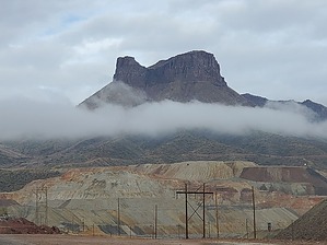
It's superior to Earl Gray! by Mike_W  Overview OverviewTeapot Mountain, at an elevation of 4485 feet, is a fitting name for this mountain because it looks like a Teapot from a distance (see photos). It's located about 1-2 miles northwest of a huge open pit mine called Ray Mine, which is roughly 10 miles south of Superior, AZ. There's an old 4x4 road going about 1.5 miles up but from there, you'll need to hike ridgelines and cross a few canyons to get to the high point. I might also add that for most of the elevation gained it's an off-trail hike, however, some good cattle trails continue for at least 1/2 mile past where I got off the road. Hike From the parking area, cross to the east side of AZ-171, go through the unlocked gate, and start walking up the old 4x4 road. I wondered how any vehicle ever got up this road. It was extremely rocky with ruts and some large-scale erosion in a few places higher up, that probably occurred over 20 years or more. I took the road for a total of 1.66 miles until I saw a small canyon to my right. The road continued northwest when I needed to go northeast, so I decided to exit the road and take the canyon for a while. The canyon started well but then got messy quickly. I took the canyon for a total of only 400 feet, then exited the canyon to the northwest and climbed up to the ridgeline which just took a few minutes. This ridgeline was a much better route than the canyon. I found some nice cattle trails which I was able to follow for about a 1/2 mile up the ridgeline. Now I needed to curve around the mountain in front of me to the saddle between Sleeping Beauty and Teapot Mountain.
Once on the top of the wide ridgeline approaching the summit, I had to walk for about 10 minutes further to get to the high point. There were a lot of boulders scattered around at the summit, so there were some excellent photo opportunities. At the high point, I found a sealed tin container that was turned upside down. When I opened it up, the entire registry was soaked and there were a few ounces of water inside the container, which I drained out. Personally, I always like to keep metal containers with the lid ON TOP, that way, if there is rain, it drips off the top and down the side. I also like to put a 5-10 pound rock on the tin to prevent it from blowing around. Anyway, I happened to have a glass jar with me so I started a new registry and secured it under a rock overhang with some smaller rocks protecting it. I left the tin there also, this time upright with a rock on top. Maybe after some sunny days, the old registry will eventually dry out and be a little more manageable/readable. On the way down, I decided to try something much safer, although not a walk in the park. Going down from the saddle was very steep but overall a much easier down climb than going along the cliffs at the top. And down lower, the brush got pretty messy and there were two steep canyons to my left and right closing in on me. Getting down to the canyon where I did was definitely not trivial, but it was the best place I could find in this immediate area. I probably would have been better off getting into the canyon earlier. If I were to do this hike again, I would use my "down route" for both up and down, so that is what I would recommend to anyone wanting to do this hike. When I got lower I found some more defined cattle trails and followed them down. Some of these trails went into and across some canyons. These cows are pretty smart at knowing where to go. They are better hikers than we know. When I got much lower, I saw a black cow about 100 feet away from me in one of the canyons. It was grazing and allowed me to get within about 25 feet away, then it ran off. I followed the cow for a while then saw 4 of its friends in another canyon. Again, I was able to get about 25 feet away from the group, and they all took off. I climbed up on the ridgeline to the south and followed cattle trails all the way down into a wider canyon at the bottom. From here I could see the old 4x4 road again. Up ahead the section of road was completely eroded away. There was about a 10-foot gap in the road that was eroded out, and the embankment was probably 10 feet high. I found a trail leading back up to the road from the canyon. Once on the road, I walked about 1.45 miles, crossing some eroded areas along the way, to get to the bottom where I parked. Gate Policy: If a gate is closed upon arrival, leave it closed after you go through. If it is open, leave it open. Leaving a closed gate open may put cattle in danger. Closing an open gate may cut them off from water. Please be respectful, leave gates as found. The exception is signage on the gate directing you otherwise. Check out the Official Route and Triplog. Note This is a moderately difficult hike. Leave No Trace and +Add a Triplog after your hike to support this local community. | ||||||||||||||||||||||||||||||||||||||||||||||||||||||||||||||||||||||||||||||||||||||||||||||