Route Editor

| Guide | ♦ | 1 Triplog | 0 Topics |
details | drive | permit | forecast | route |
stats |
photos | triplog | topics | location |
| 24 | 1 | 0 |
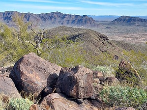
Sweet Water by DixieFlyer  Overview OverviewThe Guadu Benchmark (elevation of 2,604 feet and prominence of 1,104 feet) is the highpoint of the Cipriano Hills, which are in the western portion of the Organ Pipe Cactus National Monument (OPCNM). Etymology In 1962, when this peak was surveyed, the surveyors' dataset said that the peak was the "highest part of a small group of dark hills known as the Agua Dulce Mountains." In coming up with the name for the benchmark, the surveyors likely used the following formula: aGUA + DUlce = GUADU
The Cipriano Hills are named for Cipriano Ortega, who dug a well nearby in the early 1900s. (Source: Arizona's Names (X Marks the Place), by Byrd Howell Granger) Hike There is no trail whatsoever on this hike. From the parking area, you will go west for about a mile then head north for 0.9 miles. You can see the peak from the parking area, which will be off to your right, to the north. As you look west from the parking area, you will a saddle to the left, or south side, of the peak. That saddle will be your first target. You'll initially be hiking across the desert floor, which is mostly flat. Shortly after leaving the parking area, you'll drop into and out of a wash, and then cross a few arroyos along the way. There is some brush here and there, but it is mostly going across open country. As you get closer to the saddle you'll be gaining some elevation, and the terrain gets rocky. Once at the saddle you'll head north to what looks like the peak, but is instead a false summit. The false summit is o.5 miles away, and you'll gain 800 feet in elevation over that stretch. The slope is covered in basalt rocks and boulders, along with some unfriendly vegetation. It is not really bushwhacking, but you'll want to dress defensively. The rocks, boulders, and steepness of the slope will make the going very slow; but if you endeavor to persevere you'll eventually get to the false summit. Once at the false summit, you'll continue north for about 0.4 miles to the true summit. The going is still rocky, but not as bad as the ascent to the false summit. It is relatively flat over this stretch, which will be a relief after the climb that you just made. Enjoy the views at the summit, check out the "Guadu" benchmark, have a snack, and then return the way that you came. The descent from the false summit down to the saddle might be about as slow as the ascent, as the steepness of the slope along with the rocks and boulders can make for a treacherous descent. Warning There are a couple of things to be aware of: 1) In 2002 a park ranger, Kris Eggle, was shot and killed by members of a Mexican drug cartel who had crossed the border illegally. In the aftermath of this murder, this portion of the OPCNM was closed for 12 years. This is not likely to happen again, and the situation here is probably not worse than in other places in southern Arizona, but it is something to be aware of. 2) This hike goes up the south side of a slope to the peak, with the slope being covered in dark-colored basalt and lava rocks. As such, on a sunny day, it can feel and be much warmer than the ambient temperature. For that reason, this is basically a wintertime hike, and even then you might want to start early on a really warm and sunny day. Check out the Official Route and Triplog. Leave No Trace and +Add a Triplog after your hike to support this local community. | |||||||||||||||||||||||||||||||||||||||||||||||||||||||||||||||||||||||||||||||||||||