Route Editor

| Guide | ♦ | 2 Triplogs | 0 Topics |
details | drive | no permit | forecast | route |
stats |
photos | triplogs | topics | location |
| 112 | 2 | 0 |
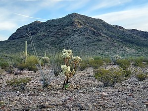
Paint it Black by DixieFlyer  Overview OverviewThere are over 50 hills, buttes, mesas, peaks, mountains, and other summits in Arizona that have the word "black" as part of their name. This particular Black Mountain (elevation of 3,008 feet and prominence of 1,328 feet) is south of the town of Ajo and is the highpoint of the Little Ajo Mountains. Black Mountain is isolated from the main mass of the Little Ajo range, which is west of Ajo. Etymology Like many Arizona geographic features with the word "black" in its name, Black Mountain is dark in appearance due to its volcanic origin.
Source: Arizona's Names (X Marks the Place), by Byrd Howell Granger Hike You can see the peak from the parking area, and the route is fairly apparent. You need to walk across the desert floor for about a half mile; then ascend a ridge southwest of a false summit for about 0.7 miles; and then go north across a ridgeline for about 0.3 miles to the peak. If only it was that simple. There is no trail whatsoever, no cairns, no painted arrows, but a good bit of rock scrambling. With some good route finding and good decision-making, you can keep the scrambling to class 2, or class 2+ at most. From the parking area, hike for 300-400 feet on the road until the road ends just before a wash. You could drive this distance if you want -- you may get some pinstripes but your car would be hidden from Bates Well Road. The wash is a bit brushy and is the only very brushy part of the hike. With a little effort, you can find a painless way to get through the brush. Once past the wash, you go across the open desert, aiming for the first ridgeline that you see. The ridgeline is fairly steep with some loose rock and has some rock outcroppings along the crest of the ridgeline that must be navigated. The author of the guide bypassed the first rock cropping on the ridgeline, but thereafter stayed on or near the crest of the ridgeline and went up and over most of the rock outcroppings. The rock was solid on the ridgeline crest, and from that standpoint was preferable to the loose rock that is encountered if you get far from the crest. The ascent steepened near the false summit, especially the last 150 feet or so of vertical. It was a relief to get to the false summit, but there was still work to do to hike to the true summit, about 0.3 miles away. There is another ridgeline to follow on the traverse. Again, it seems best to stay on the ridgeline. The ridgeline is fairly narrow in places, but it is by no means a knife edge. In places, there are some steep dropoffs on one or both sides of the ridgeline, so those with a fear of heights might be uncomfortable. From a distance, some of the rock outcroppings on the ridgeline appear daunting, but as you get closer to them things aren't so bad after all. Those who enjoy rock scrambling will likely have fun on this traverse. The summit block is nice, so once there it is worthwhile to hang out a bit and enjoy the views. Return the way that you came. Synopsis This is a tough little hike, and you need to be adept at rock scrambling to enjoy it. Check out the Official Route and Triplogs. Note This is a moderately difficult hike. Leave No Trace and +Add a Triplog after your hike to support this local community. | |||||||||||||||||||||||||||||||||||||||||||||||||||||||||||||||||||||||||||||||||||||