 Route Editor

| Guide | ♦ | 4 Triplogs | 0 Topics |
details | drive | no permit | forecast | 🔥 route |
stats |
photos | triplogs | topics | location |
| 11 | 4 | 0 |
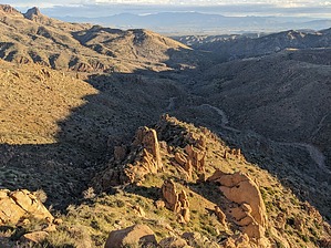
Noniconic Supes Refuge by pseudalpine  Overview OverviewFor a few decades, this elevated fortress has colloquially been known as the Superstition Citadel (and more boringly, Saddle Horn Peak 4726). Surrounded by numerous monoclinal elfin guards and eminently perched above Campaign Creek, it bestows a commanding view of the winsome northeast Superstition Wilderness. It may also offer a few challenging climbs, for those inclined. Hike From the Upper Horrell TH, attempt to track the Campaign "Trail" #256 for 2.3 miles north. There are a few distinctively large boulders on creek right (west) that help identify where one should leave the drainage. Since I first climbed this peak, four years ago, eight months post Woodbury Fire, the Chaparral is dominantly retaking this landscape. Regardless, there's still a minimally bushwacky route that ascends the steep hillside up to and through the soldiers, eventually gaining the stronghold's northeast face. The route requires some lower third class scrambling midway up, but then the pitch decreases for a bit until below a southern col. The granite alternates between coarse and fine, but luckily around on the final south side, the texture is almost perfect through some minor steep shelves to the burnt summit sanctuary.
No summit cairn or register has ever been present, but I'm sure other (likely endemic and maybe non-indigenous) humans have been at this special zenith. My first scramble up to this peak was via the south side, but I'd prefer not to guide anyone to the scary route I ascended. This area is an anomalous Superstition terrain with crystallized dikes, weird machicolated features and dark xenoliths. Note From the Upper Horrell TH, this roundtrip summit hike totals six miles and about 1700 feet AEG. Check out the Official Route and Triplogs. Leave No Trace and +Add a Triplog after your climb trip to support this local community. | |||||||||||||||||||||||||||||||||||||||||||||||||||||||||||||||||||||||||||||||||||||||||||||||
 Rated
Rated


