Route Editor

| Guide | ♦ | 1 Triplog | 0 Topics |
details | drive | no permit | forecast | route |
stats |
photos | triplog | topics | location |
| 21 | 1 | 0 |
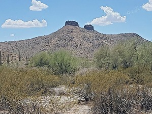
OK, I hiked it because of the name Squaw Tits, but it was very nice by Mike_W  Overview OverviewThe Isanaklesh peaks, also known as Squaw Tïts (I like this name MUCH better) on most topo maps, is a low-elevation desert hike in the Sand Tank mountains to a pair of rocky tïts, I mean peaks, with one of them being slightly larger than the other, with an elevation of only 2,478 feet. When driving in, you will be able to tell how these truly unique peaks got their name. They look just like a pair of tïts with nipples included, and the name alone was one of the main reasons I decided to do this hike. This is a low-elevation hike that would be best done in winter. This is an open Country hike with some exposed class 3 scrambling near the top; there is no trail. Hike On the drive in, you will be able to get some views of the tits, and they should be visible from the area where you parked, but if not, within a few minutes walk from where you parked. I followed one ridgeline up and another down, so there are at least 2 good options for routes. You could do a counter-clockwise loop, like I did, or just follow one of the ridgelines up and down.
The terrain will be very rocky at times, and you'll see the typical desert plants like palo verde, ocotillo, cholla, saguaros, creosote, etc. The hike up to "the nipple" is quite steep and you'll need to do some weaving to avoid various desert brush and cactus. The nipple area is actually made up of a lot of coarse and jagged rocks and there are cavities on the cliff side where birds have nested. When I was there, I saw many vultures circling around in the rocky nipple area. At the base of the nipples, it's probably another 50-60 vertical feet to get to the top. The climb is a bit steep and isn't trivial, at least using the route I ended up going. I ended up climbing up a steep area on the Northeast side which was a class 3, at times. The danger here is some of the rocks are crumbly, so definitely make sure you have 3 points of contact on these steeper sections. If you are not comfortable climbing this, you can look for a better way up, or skip going to the top. Eventually, I made it to the top and found an old rusted 55-gallon drum up there. There was also a registry under a rock pile. From the top, I could look Northwest at the other nipple which was about 400 feet away. There was another 55-gallon drum up there and I wondered how anyone got those drums up there. They probably had to hoist them up using rope. I decided to take a slightly different route down from the top that was further Northwest. This route had a little less exposure and felt safer going down. I just took my time and made it down safely to the base of the nipple. Once at the base of the nipple, you can relax because that was the most challenging part of the hike. By the way, the other nipple to the Northwest looked harder to summit, but I didn't examine it closely. I only went to the saddle between the two nipples. And since it was nearly a 100-degree day when I was there, I didn't have much interest in climbing the second tït. It was hard to tell which one was higher but I was glad the registry was on the first tït and not the second. On the way down, I followed the ridgeline heading East, which felt easier than the ridgeline I took up. In terms of distance, my route going down was about 0.2 miles shorter. Partway down the East ridgeline I found some migrant trash near a palo verde tree, including a pan used to cook something. Not sure why they would be here, in all places. It's very remote and it's pretty far from any town. All in all, it was an interesting hike and my ONLY regret was hiking it in July when it was really too HOT for this hike. Check out the Official Route and Triplog. Leave No Trace and +Add a Triplog after your hike to support this local community. | ||||||||||||||||||||||||||||||||||||||||||||||||||||||||||||||||||||||||||||||||||||||||