 Route Editor

| Guide | ♦ | 2 Triplogs | 0 Topics |
details | drive | permit | forecast | route |
stats |
photos | triplogs | topics | location |
| 12 | 2 | 0 |
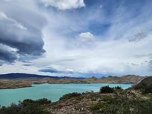
Hiking in a Magical Wonderland! by Vashti This hike is part of the W trek in the Las Torres National Park in Chilean Patagonia. Warning Weather in Patagonia is unpredictable, even in the summer. Be prepared for rain, wind, sleet, and snow, even on a day that starts sunny and beautiful. Pack appropriate layers.
The hike begins at Frances Sector. We left the Domo after breakfast armed with our boxed lunches and our full packs in a light rain. The trail is level through the forest for a while before descending to Refugio Cuernos (horns, named after the mountain nearby). Cuernos has a refugio, a campground, and elevated tents. We passed by and continued. The rain stopped, and the wind began. Anytime we were not in the forest, the wind was fierce. Like blow you back and almost knock you off your feet fierce. We later heard the wind reached 50 km/hr, with gusts even higher. The trail is easy to follow and generally parallels the coast of Lake Nordenskjold. It was especially windy at the beach of the lake and on exposed ridges. The views are fantastic of the lake, rivers, and mountains. There are several river crossings. Some have suspension bridges, and others you hop rocks to get across. Nothing treacherous. After following the lake shore for a while, the trail heads inland where the wind quiets down. Not too long after you head uphill to a great lookout with an enormous rock shelf overlooking the lake below. This is a perfect spot to stop and have lunch. Everyone else thought so as well, and so we bypassed the 20+ hikers and trekked on. Continuing, you come upon a signed junction for the Chileno Sector to the left. Head to the right to go to the Central Sector. Lago Enge is up next. It's very beautiful, but it also marks the end of the forest coverage. As a result, the last three miles are through open land, and thus the wind was vicious and without end. The landscape is very beautiful in this area, but a little hard to enjoy in the driving wind. My hat brim was plastered back to my head, and many unsecured items were blowing off other hikers (hats, pack rain covers, etc.). The mountains are on the north side of the trail, and as the trail descends into the valley, there are expansive views of nearby lakes. Hotel Las Torres comes into view. Just before a large wooden suspension bridge river crossing is a signed junction for the trail up to the base of Las Torres (the Towers). The refugio Central is one mile away at this point. There are no signs for the refugio, but there are signs for the campground. The refugio is just beyond the campground. Las Torres National Park is well worth the travel to see! Note: A ticket is required for admission into Las Torres del Paine National Park. Tickets can be purchased online. Check out the Official Route and Triplogs. Leave No Trace and +Add a Triplog after your hike to support this local community. One-Way Notice This hike is listed as One-Way. When hiking several trails on a single "hike", log it with a generic name that describes the hike. Then link the trails traveled, check out the example. | |||||||||||||||||||||||||||||||||||||||||||||||||||||||||||||||||||||||||||||||||||||


