Route Editor

| Guide | ♦ | 3 Triplogs | 0 Topics |
details | drive | no permit | forecast | route |
stats |
photos | triplogs | topics | location |
| 73 | 3 | 0 |
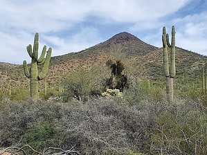
drug runner's paradise by Mike_W  Overview OverviewAntelope Peak, at an elevation of 3,117 feet, is in the Table Top Wilderness area and is an open Country hike with a rock scramble to get to the top. Some washes can be used to travel east, or you can just walk across the rolling hills. The mountain is near the Vekol Ranch which has been abandoned. The road used to get to a good starting point passes by the Vekol Ranch. You can take a look at the ranch assuming it's still abandoned. Hike We started hiking to the east and immediately reached a wide sandy wash. We crossed the wash and entered an open Country area which was easy to cross. We continued until after we hiked a total of 0.7 miles and reached a wash. We stayed in the wash until after hiking a total of roughly one mile, then exited the wash on the south side. After hiking a total of 1.43 miles, we crossed another wash and started heading up the west ridge toward Antelope Peak. We later realized that we were crossing the same wash each time, which was an "S" shaped wash. On the climb up, there was a lot of lava rock but the brush wasn't bad at all. We needed to weave a bit to avoid obstacles.
We took a similar route down but decided to hike further south hitting the wash earlier. Then, we hiked through the S-shaped wash back to the starting point to avoid having to walk the open Country area. We thought that it would be nice to see some different scenery. On the drive out, we stopped at the old Vekol ranch and looked around. The main house had 2 very nice and large patios, there was a nicely constructed stone wall that someone put a lot of time and work into. We also found some kind of lookout tower which we didn't know what it would have been used for. We wondered why the property was abandoned and for how long. On one of the concrete slabs on one of the smaller buildings, I saw a date of 1971 carved into the cement. This was probably when a lot of the construction took place. Check out the Official Route and Triplogs. Leave No Trace and +Add a Triplog after your hike to support this local community. | |||||||||||||||||||||||||||||||||||||||||||||||||||||||||||||||||||||||||||||||||||||||||||||||