History: This beautiful valley sits in the shadow of the Sierra Buttes. It has been shaped by three historical events. The first being the glacial age. There is evidence of this time in the granite boulders that litter the valley. The second being the mining era, the Young America Mine deposited their tailings in the bottom of the valley. Later, miners excavated some of these mine tailings for further processing which created a depression. The depression eventually filled with water creating Sand Pond. The third event being the migration of beaver to this area. The beaver dammed the Sardine Creek creating a marsh which killed a substantial amount of the trees.
Overview: The Sand Pond Loop exposes evidence of these three events on a family friendly comfortable hike that most have the ability to hike.
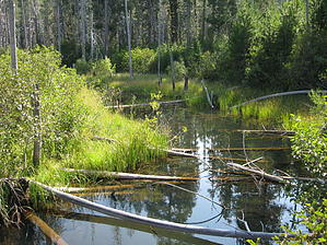
Hike: The trailhead is at the sandy beach at Sand Pond which provides a nice swim at the end of the hike. The hike proceeds for a distance along an old flume that once ran 4.5 miles to a mill site in Sierra City, Ca. There is ample shade in this area from old growth forest making it comfortable even in summer. Many boulders liter the trail side and at an opening in the forest the hill side is peppered with boulders the glaciers left behind. The trail now enters a meadow which was obviously a wetland at one time. Dead tree trunks abound. As the trail enters a marsh there is a boardwalk to protect it. This boardwalk passes by several old beaver dams. A wooden bridge brings you over Sardine Creek. With fresh clear water flowing, show a little patience and you are sure to see some wild life. The trail leaves the boardwalk back into old growth forest as it returns to Sand Pond. There are restrooms and a change house at the trailhead to facilitate water recreation.
WARNING! Hiking and outdoor related sports can be dangerous. Be responsible and prepare for the trip. Study the area you are entering and plan accordingly. Dress for the current and unexpected weather changes. Take plenty of water. Never go alone. Make an itinerary with your plan(s), route(s), destination(s) and expected return time. Give your itinerary to trusted family and/or friends.
Permit $$
None
Directions
Road
FR / Dirt Road / Gravel - Car Okay
To hike On Highway 49, approximately five miles east of Sierra City, turn north onto Gold Lake Highway at Bassetts Station. Continue for about 1.4 miles, turn left at Salmon Creek bridge, and proceed west toward Sardine Lake for approximately one mile to the Sand Pond Swim Area parking lot.
 Route Editor