Route Editor

| Guide | ♦ | 5 Triplogs | 0 Topics |
details | drive | permit | forecast | map |
stats |
photos | triplogs | topics | location |
| 82 | 5 | 0 |
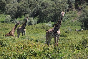
Steep hike with giraffes by gummo Mount Longonot is protected by the Kenya Wildlife Service as part of Mount Longonot National Park. It starts at the Longonot Centre. For foreigners, it is $27 to enter the park - as of 2024. You need to use eCitizen's website to purchase the ticket, which unfortunately, doesn't always work, so you have to ask a local to purchase the ticket using M-Pesa (Kenya's mobile money), and you pay them back. It is recommended that you hike with a guide, which costs between 2000KSH to 3500KSH - depending on how long you hike.
At around 1.2 miles, you will see a sitting area with shade where many stop. It proceeds to get steep, but the park service installed stairs and laid concrete to help get to the top. Zebras and cape buffalo are commonly seen on this part of the trail. Other wildlife like giraffes, elands, waterbucks, and reedbucks can be seen to the left of the trail in the distance and on the alternative route going down. At the top, you will see the crater and the trail that loops around the rim. You can choose to hike the loop, which can take 2 to 3 hours, or you can go down the trail you came. You can also go down the alternative trail to the left, which adds a half mile to your hike and brings you closer to the giraffes and other wildlife that were seen on the way up. There are no lions in this area, only leopards and hyenas. If you decide to complete the loop, you will see that you can also go down into the crater. It is very steep, and most folks don't go down because it is steep. Baboons are commonly seen in the crater and occasionally seen on the hike down. When hiking Mount Longonot, sneakers are okay, but the trail can be slick. There are no loose rocks, but slipping can occur because it is steep. Longonot Centre offers free walking sticks to use to avoid slipping. The centre also sells water and snacks. They do not allow plastic bottles on the hike, but you can purchase a reusable bottle at the trailhead for $1. This is a beautiful and safe hike and a nice break from Nairobi. It's a bit dusty and little shade, but temperatures are mild. You can go to Lake Naivasha afterward to enjoy a boat ride or a meal by the water if you don't want to head back to the city right away. The park is open from 6am to 6pm. Check out the Triplogs. Note This is a more difficult hike. It would be unwise to attempt this without prior experience hiking. Leave No Trace and +Add a Triplog after your hike to support this local community. | |||||||||||||||||||||||||||||||||||||||||||||||||||||||||||||||||||||||||