Route Editor

| Guide | ♦ | 2 Triplogs | 0 Topics |
details | drive | permit | forecast | map |
stats |
photos | triplogs | topics | location |
| 124 | 2 | 0 |
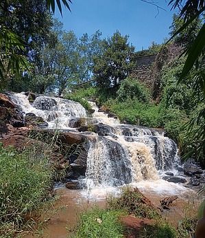
Nairobi urban trails by gummo Overview: Karura Forest is 2,570 acres consisting of three parts separated by Limuru and Kiambu roads. As of mid-2016, 36% of the forest contains indigenous upland forest tree species. The forest is home to some 200 species of birds as well as bushbucks, bush pigs, genets, civets, bush babies, porcupines, Syke's monkeys, bush squirrels, hares, fruit bats, dik-diks, various reptiles, and many butterflies. Karura now has over 50 km of trails for visitors to walk, run, or bike.
Reserve: Karura Forest is similar to Central Park, as it is a place to escape city life for a short time. The cost for foreigners is 600KSH (200KSH for residents). Karura Forest has a network of trails that lead you in all directions. The main attraction is the Mau Mau Caves and the waterfalls. It has at least 2 waterfalls, of which one is hidden and far from the main trail. The other waterfall is near the Mau Mau Caves and receives most of the visitors. You can enter the forest in various locations, but the most popular entrances are Gate C and Gate A. No plastic bottles are allowed in the forest. When you enter the forest, you will notice how quiet it gets from the noisy city surrounding the park. You can visit some of the shallow lakes that often dry up and follow the stream that passes thru the park. Bike rentals run about 500KSH for 2 hours. You will need a passport to rent a bike. Bikes are usually not in good condition. Hiking the trails consists of shady, often damp areas with some inclines in the center to fields, marshes, and sun exposure along the outskirts bordering the city. Butterflies are plentiful. Raptures are commonly seen and quick to fly away when people approach.
Check out the Triplogs. Leave No Trace and +Add a Triplog after your hike to support this local community. | |||||||||||||||||||||||||||||||||||||||||||||||||||||||||||||||||||||||||||||||||||