Route Editor

| Guide | ♦ | 1 Triplog | 0 Topics |
details | drive | permit | forecast | route |
stats |
photos | triplog | topics | location |
| 24 | 1 | 0 |
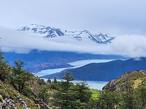
Day 1 of the W Trek, West to East by Vashti The weather in Patagonia is unpredictable, even in the summer. Be prepared for rain, wind, sleet, and snow, even on a day that starts sunny and beautiful. Pack appropriate layers. Overview This hike is part of the W trek in the Las Torres National Park in Chilean Patagonia.
This is a common starting and ending point for the W trek. As a result, the hike can be a bit rushed. If starting with this hike as day 1, you only arrive to the Paine Grande area at 11a or noon after catching the earliest ferry available from Pudeto. Alternately, if it is your last day, you are rushing to complete the hike before having to depart on the ferry in the afternoon. In 20/20 hindsight, I would have allowed for an extra night so that we could have made it all the way to Grey Glacier. Another timing concern is the scheduled dinner time. If you elect to have dinner at the refugio, you are provided with a scheduled dinner time, thus if you can only start hiking at noon, and you have to be back by your dinner slot, then you are gated by constraints on both sides. Something to consider when planning your trip itinerary! Exiting the hostel, you head away from the ferry dock and towards the new park ranger office (a beautiful new stately building). At the ranger station, there is a junction. Straight heads over to the Italiano sector, which is day 2 of the W trek if you are going West to East. Turning North/Northwest at the junction sets you on the path towards Grey Glacier. Initially, you are in a canyon until you climb up slightly to a ridge. From here the views begin, of beautiful lakes, some with ice floes, and also of mountain majesties if you are lucky enough to have a clear day on the trail! There are several lookouts on the way along with accompanying interpretive signs which also show the trail elevation profile as well as a you are here marker on the trail depiction. The first lookout is a lake overview. The second overview is the halfway point to Grey Glacier and the day hike turnaround point for most day hikers. This lookout has a spectacular panoramic view of the area, including the glacier, lake, and mountains. All the goodness!! We decided to continue on in an attempt to reach glacier Grey before having to turn around in order to meet our scheduled dinner time. As you continue on the trail, you abruptly lose all the elevation gained, and you are in a more forested area though the glacier can still be spotted heading towards the lake. There are a number of streams and waterfalls in this area. Also, many prolific wildflowers, the most spectacular being foxglove. I have never seen foxglove grow in the wild, and really it is a site to behold! It grows in large swaths, and it makes for quite a sight, especially in the bright fuchsia pink. There is also white, as well, but the pink is arresting. At about this time, our weather started degrading. And sadly, this is where I learned that apparently, the coating on my raincoat was no longer waterproof. Sigh. This was a very sad state of affairs indeed, and it made for a most miserable cold and wet hike. It is tough to accept that you thought you were prepared, but then you were not. Always check your gear before you go!! :/ Given the cold and wet broken raincoat misery along with the time constraints for dinner, we sadly turned around before arriving at Grey Glacier. Despite this, the journey was amazing! There were waterfalls and wildlife (large bird, a hawk maybe?) along the way. We retraced our steps and made it back to the refugio in time for dinner, yay! Handily, there are 2 rooms with wood-burning stoves and drying racks to dry your wet gear. And the mini-mart sells rain ponchos in case you need one! Water Sources A number of small and large streams are crossed on this trail. All are suitable to get water. Camping Camping is allowed at the beginning and end of this hike, but only by reservation. In addition to camping, there are refugios, as well. Refugios are full-service Hostels with beds. Reservations must be secured in advance. There is a minimart, showers, and food available for purchase. At large camping is not allowed. Note A ticket is required for admission into Las Torres del Paine National Park. Tickets can be purchased online. Gate Policy: If a gate is closed upon arrival, leave it closed after you go through. If it is open, leave it open. Leaving a closed gate open may put cattle in danger. Closing an open gate may cut them off from water. Please be respectful, leave gates as found. The exception is signage on the gate directing you otherwise. Check out the Official Route and Triplog. Leave No Trace and +Add a Triplog after your hike to support this local community. | |||||||||||||||||||||||||||||||||||||||||||||||||||||||||||||||||||||||||||||||||||||