|
tap row or icons for details
|
| Difficulty |
|
0.5 of 5 |
| Route Finding |
|
1 of 5 |
| Distance Round Trip |
|
2.6 miles |
| Trailhead Elevation |
|
13 feet |
| Elevation Gain |
|
-4 feet |
| Accumulated Gain |
|
73 feet |
| Avg Time Round Trip |
|
1 hour |
| Kokopelli Seeds |
|
2.97 |
| Interest Historic & Perennial Creek | | Backpack No | |
| | |
|
|
| |
|
|
Historical Weather |
| Trailhead Forecast | | |
|
 |
|
|
| Preferred Jan, Dec, Feb, Mar → 7 AM |
| |
|
|
| | |
| |
Named Locations Coordinate Links
| |
|
|
Marsh Trail - Ten Thousand Island...
|
2.7 mi
83 ft |
 |
| | |
| |
|
|
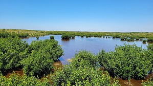
 Located in the Ten Thousand Islands National Wildlife Refuge, the Marsh Trail is a good spot to stretch your legs if you are in the area. It has a rich history and lots of plants and animals to see. Long ago, the Calusa Indians lived here. Bird lovers will have a field day spotting herons, egrets, and ospreys flying around. Keep an eye out for marsh rabbits and river otters too! Alligators can be spotted sunning themselves. Early in the morning is best for viewing alligators and birds.
There is an observation tower close to the end of the trail, that allows you to get a better chance to see wildlife, including fish.
The Marsh Trail is an easy walk on an old, flat, smooth road. It's also a place where nature shows off its balance. Every plant and animal here plays a part in keeping this ecosystem healthy.
|
 Route Editor