Route Editor

| Guide | ♦ | 1 Triplog | 0 Topics |
details | drive | no permit | forecast | route |
stats |
photos | triplog | topics | location |
| 0 | 1 | 0 |
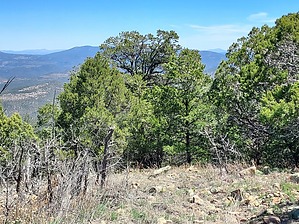
bear if you dare by DixieFlyer  Bear Mountain (elevation of 8,036 feet and prominence of 1,476 feet) is in the Gila National Forest and is near the town of Silver City in southwestern New Mexico. Hike From your parking spot go to the end of the road and you can pick up the trail. The trail is maintained and easy-to-follow, so once you are on the trail simply follow it to the top of the mountain. The trail is heavily wooded, so views are limited on the way up. The summit is also wooded, although there are some expansive views off to the north. Some interesting peaks are in the distance, including Whitewater Baldy and Mogollon Baldy.
Spring and Fall are the best times to do this hike. It can be hot in the summer and snowy in the winter, although if you pick your spots you can hike in summer/winter. Synopsis This hike is short, sweet, and steep. Unless you are a peakbagger, it is not worth driving to Silver City solely to hike to this peak. However, if you are in the area the hike is a good short workout, and you can do this hike as an add-on to some other hikes that you may be doing in the area. Check out the Official Route and Triplog. Leave No Trace and +Add a Triplog after your hike to support this local community. | ||||||||||||||||||||||||||||||||||||||||||||||||||||||||||||||||||||||||||||||||||||||||||||