username
X
password
register
for free!
help
  🔥

Mineral Creek Trail #201 at Cooney Canyon, NM

Guide 5 Triplogs  0 Topics
  4.5 of 5  
Fav
Wish
0
details
drive
no permit
forecast
🔥
route  
stats
photos
triplogs
topics
location
68 5 0
HAZ reminds you to respect the ruins. Please read the Archaeological Resources Protection Act of 1979 & Ruins Etiquette
Statistics
tap row or icons for details
Difficulty 3 of 5
Distance Round Trip 14.6 miles
Trailhead Elevation 5,427 feet
Elevation Gain 800 feet
Accumulated Gain 800 feet
Avg Time Round Trip 8 hours
Kokopelli Seeds 18.6
 Interest Ruins, Historic, Seasonal Waterfall, Perennial Waterfall, Seasonal Creek & Perennial Creek
feature photo
Photos Viewed All MineFollowing
Inaugural Calculation on Button Tap!
12  2024-11-15 Jackluminous
21  2024-08-05
Mineral Creek Trail
markthurman53
16  2024-05-06 The_Eagle
19  2022-11-06
Mineral Creek Trail #201 to Cooney Mine
Jackluminous
Author
author avatar Guides 41
Routes 1,626
Photos 14,983
Trips 2,762 map ( 18,602 miles )
Age 69 Male Gender
Location Far NE Phoenix, Az
Historical Weather
Trailhead Forecast
Radar Map
Expand Map
Preferred Mar, Nov, Feb, Apr → 7 AM
Sun  5:52am - 6:36pm
Official Route & 2 Rts
 
3 Alternative
 
Historic Fire Perimeteracres
🔥 2012 Whitewater-baldy Complex 297.8k


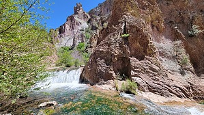
Minerals in Cooney's Craggy Canyon
by The_Eagle

Warning
The area is prone to flash flooding, be aware of the area's weather.


The Mineral Creek Trail #201 in Cooney Canyon, Alma NM, offers an adventurous journey through a landscape rich in history and natural beauty. You'll discover the area's fascinating past and diverse wildlife as you hike this trail.
remove free decal offer
Cooney Canyon has a long history, with evidence of Native American habitation dating back thousands of years. Later, European settlers arrived, drawn by the region's abundant natural resources. The area is once home to ranchers and in the past, miners. Mining relics can be found along this trail. The tall cliffs and interesting geology make this a treat to hike.

Note
About a mile before you reach the TH, is Cooney's Tomb. This historic site is believed to be the final resting place of John Cooney, a local rancher, and his family. It was carved out of a boulder and then sealed. There are 5 or 6 other graves in the area.

In May, when I hiked this, Mineral Creek was flowing well. Don't even bother trying to keep your feet dry. A hiking pole will be helpful in the many crossings of Mineral Creek.

There is room for tents at the TH

This hike was a hidden gem for me.

Note
This hike is advertised as a 14.6 mile out and back. I did not hike to the end and can't vouch for the Trail tread/conditions for the entire length. Gila National Forest says the area was thinned in 2017.

2024-05-11 The_Eagle


    Check out the Official Route and Triplogs.
    Leave No Trace and +Add a Triplog after your hike to support this local community.
    WARNING! Hiking and outdoor related sports can be dangerous. Be responsible and prepare for the trip. Study the area you are entering and plan accordingly. Dress for the current and unexpected weather changes. Take plenty of water. Never go alone. Make an itinerary with your plan(s), route(s), destination(s) and expected return time. Give your itinerary to trusted family and/or friends.

     Permit $$
    None


     Directions
    or
     Road
    FR / Dirt Road / Gravel - Car Okay

    To hike
    From the town of Alma, Mineral Creek Road is just a 100' south of the general store and restaurant. Take Mineral Creek Road 5.5 miles to the end for the TH
    page created by The_Eagle on May 11 2024 8:12 pm
     90+° 8am - 6pm kills
    helpcorrectionissue

    end of page marker