username
X
password
register
for free!
help


San Francisco Hot Springs #250 Trail, NM

Guide 2 Triplogs  0 Topics
  3 of 5  
Fav
Wish
0
details
drive
no permit
forecast
route  
stats
photos
triplogs
topics
location
8 2 0
Statistics
tap row or icons for details
Difficulty 2.5 of 5
Route Finding 2 of 5
Distance Round Trip 4.02 miles
Trailhead Elevation 5,012 feet
Elevation Gain 660 feet
Accumulated Gain 660 feet
Avg Time Round Trip 2:15 hours
Kokopelli Seeds 7.32
 Interest Historic, Seasonal Creek & Perennial Creek
unreported if dogs are allowed
editedit > ops > dogs to adjust
feature photo
Photos Viewed All MineFollowing
Inaugural Calculation on Button Tap!
9  2024-08-08
San Francisco Hot Springs
markthurman53
8  2024-05-07 The_Eagle
Author
author avatar Guides 41
Routes 1,626
Photos 14,983
Trips 2,760 map ( 18,597 miles )
Age 69 Male Gender
Location Far NE Phoenix, Az
Historical Weather
Trailhead Forecast
Radar Map
Expand Map
Preferred Mar, Nov, Feb, Apr → 7 AM
Sun  5:52am - 6:36pm
Official Route & 1 Rt
 
0 Alternative


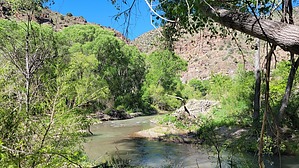
More warm than hot - Shovel Required
by The_Eagle

 
Overview
The San Francisco Hot Springs Trail is a moderately challenging 3+ mile out-and-back hiking trail located in the Gila National Forest of southwestern New Mexico. The trailhead is situated along US Highway 180, between mile markers 58 and 59, south of the town of Glenwood


Hike
The trail winds through a typical New Mexico desert landscape of rolling hills and sparse vegetation before descending into a lush riparian area along the San Francisco River. The trail is gradual and easy until reaching the gate. After that, it can become steep and rocky in places. Once at the bottom, the trail may change yearly based on flooding and debris. I found no hot springs on the descending side of the river.
remove free decal offer
After crossing the San Francisco River, I found one rock-lined "Warm Spring" that would need to be dug out before soaking. Supposedly, there is a series of primitive hot springs ranging from 100 to 120°F, depending on the season. The hot springs are located both along the river and inland, with the inland spring featuring a mud bottom. Be prepared to dig out the hot springs if they have been washed out by the river.

History
Historically, this area was part of the ancestral homelands of the Apache and Pueblo peoples

Camping
Overnight camping is prohibited, but there is BLM land nearby for camping.

Gate Policy: If a gate is closed upon arrival, leave it closed after you go through. If it is open, leave it open. Leaving a closed gate open may put cattle in danger. Closing an open gate may cut them off from water. Please be respectful, leave gates as found. The exception is signage on the gate directing you otherwise.

2024-05-12 The_Eagle


    Check out the Official Route and Triplogs.
    Leave No Trace and +Add a Triplog after your hike to support this local community.
    WARNING! Hiking and outdoor related sports can be dangerous. Be responsible and prepare for the trip. Study the area you are entering and plan accordingly. Dress for the current and unexpected weather changes. Take plenty of water. Never go alone. Make an itinerary with your plan(s), route(s), destination(s) and expected return time. Give your itinerary to trusted family and/or friends.

     Permit $$
    None


     Directions
    or
     Road
    Paved - Car Okay

    To hike
    Located along the westside of US Highway 180, between mile markers 58 and 59, south of the town of Glenwood
    page created by The_Eagle on May 12 2024 2:07 pm
     90+° 8am - 6pm kills
    helpcorrectionissue

    end of page marker