|
tap row or icons for details
|
| Difficulty |
|
4 of 5 |
| Route Finding |
|
2 of 5 |
| Distance One Way |
|
2.25 miles |
| Trailhead Elevation |
|
7,013 feet |
| Elevation Gain |
|
1,578 feet |
| Accumulated Gain |
|
1,847 feet |
| Avg Time One Way |
|
2 hours |
| Kokopelli Seeds |
|
8.41 |
| Interest Historic & Peak | | Backpack Yes & Connecting | |
| | |
|
|
29 |
2015-09-23 | JimmyLyding |
|
|
22 |
2009-09-20 | AZLOT69 |
|
| |
|
|
|
list |
map |
done |
Northern Region |
| | |
|
| |
|
|
Historical Weather |
| Trailhead Forecast | | |
|
 |
|
|
| Preferred Jul, Aug, Sep, Jun → 8 AM |
|
|
|
Seasons Early Summer to Late Autumn |
|
|
| | |
| |
Named Locations Coordinate Links
| |
|
| Sierra Buttes Lookout
|
7.6 mi
2,450 ft |
|
|
| | |
| |
|
|
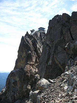
This Hike Will Kick Your Butte by AZLOT69  History: History: The Sierra Buttes are a dominant feature of the Lakes Basin and can be seen from most trails. These mountains were created about 350 million years ago by volcanic activity and are made up of Metamorphic Rock containing Quartz Porphry. Gold was discovered in the area in 1849 and in the years that followed eleven mines and twenty arrastras were situated in and around Sierra Buttes. In 1869 one of the largest gold nuggets ever found in California was located here at the Monumental Mine. It was 106 pounds. The lookout, now abandoned is the highest fire lookout in northeastern California. At one time all prominent peaks in this area were equipped with fire lookouts. Several of these were phased out in the 1970s, replaced by modern technology. For one hundred years miners and locals utilized ladders to access the peak. In 1964 the forest service built metal stairs, handrails and platforms for a safer and more permanent access. While the lookout is not used, the trail offers access to the top of the lookout and the steel grate balcony surrounding it. Overview: The Sierra Buttes Lookout can be accessed by a variety of trails with varying difficulty, distance and elevation gain. The trail as described here is straight forward medium distance and medium elevation gain. Most people can accomplish this hike and reap the rewards offered at the peak. Hike: From the trailhead you can see your destination. A lookout tower sitting precariously on top of the Sierra Buttes. The trail starts on an old fire road and starts climbing immediately. The trail gains 1847 feet in 2.25 miles so there is little break in the effort required. Narrowing down to a single track the trail is rocky and dusty as it crosses a dry slope which is alive with flowers in the spring. The views of the Lakes Region are amazing and offer great excuse to pause and take pictures while catching your breath. The snow pack lasts well into summer and there are snow fields on the north side of the jagged granite buttes which last year round. The Pacific Crest Trail shares this trail initially but takes the first junction to the right. Shortly after, a trail enters from the left. This trail originates at Tamarack Lake adding quite a bit of elevation. Continuing straight the trail comes to an area that may have 4 x 4s parked. This is the easiest trailhead, accessed strictly by 4 x 4. The climb gets serious now and serpentines thru old forest for shaded effort. The trail comes back out onto an old access road to the top. The final stretch has full exposure to the sun and elements. The views are incredible of the Yuba Basin to the southwest. Equally dramatic is the Gold Lakes Basin to the northeast. The final drive to the top brings you to the jaw dropping lookout situated high above. If you are sensitive to heights and exposure you may not continue. There are about two hundred steps on three metal staircases to get to the top. Once on top you can view the Sacramento Valley, Mohawk Valley, Mt Rose, Mt Shasta, and Mt Lassen. Below lies Young America Lake, Sardine Lake and several other bodies of water. The reward is awesome on top. Look around for writings on some of the boulders from adventurers 150 years ago who left their mark. When you have had your fill you get to enjoy the panoramic views all the way back to the trailhead, returning the way you came. Check out the Triplogs. NoteThis is a moderately difficult hike. One-Way NoticeThis hike is listed as One-Way. When hiking several trails on a single "hike", log it with a generic name that describes the hike. Then link the trails traveled, check out the example. |
 Route Editor


