Route Editor

| Guide | ♦ | 4 Triplogs | 0 Topics |
details | drive | no permit | forecast | route |
stats |
photos | triplogs | topics | location |
| 46 | 4 | 0 |
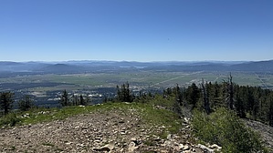
North Idaho's Mt Ord by LindaAnn Hike: Starting from the north end of the main parking lot for Rathdrum Mountain Park head up StormKing Pkwy Trail, which is a gated off forest road. The ascent is fairly gradual as the road heads uphill to the northwest. Views are limited due to the dense vegetation, but the road is in good shape, making for easy hiking. The trail continues uphill, mostly north, then west as it makes its way to a radio tower at about the 3.50 mile mark.
At about 5.75 miles, you'll reach probably the most important route-finding turn of the hike. There will be a dirt bike trail turning right, straight up a steep slope. It is not well marked but is a distinct trail. The climb up this little trail is short, maybe only a tenth of a mile, but you'll gain a quick 150'. Nearing the top of this climb, stay on the most well-traveled trail as it turns left and reaches a large saddle. There are four road options at this saddle, take the one to your right, heading northeast. Common sense will prevail here as Rathdrum Mountain is to your east at this point. Continue following the road to the northeast, then east, passing another gate. Great views open up to your north, including Twin Lakes just below, and more of the Selkirk Range as it stretches north. Mount Spokane features prominently to the west. A glimpse of the Rathdrum Summit is visible as well. The condition of the road deteriorates as you continue, and gets notably steeper. The road switchbacks steeply up the north side of the peak and has more loose rock. Enjoy the views as you push uphill. The summit buildings pop into view, and the small summit is mostly tree free. There are also some good views of the Cabinet Mountains to the east. There are a couple of small buildings and some propane tanks, but there are some rocks to sit on and a clear, flat area on the south side of the summit. Once done, retrace your steps back downhill. Once on the lower part of StormKing Pkwy, you can opt to descend Majestic Passage Trail to shave off a little bit of distance. This slight detour is well worth it, as the upper part of that trail switchbacks almost comically thru large cedar trees. Once you reach the disc golf course, cross the footbridge to the south side of the creek and follow the trail back to the trailhead where it reconnects with StormKing just before the parking lot. Gate Policy: If a gate is closed upon arrival, leave it closed after you go through. If it is open, leave it open. Leaving a closed gate open may put cattle in danger. Closing an open gate may cut them off from water. Please be respectful, leave gates as found. The exception is signage on the gate directing you otherwise. Check out the Official Route and Triplogs. Leave No Trace and +Add a Triplog after your hike to support this local community. | |||||||||||||||||||||||||||||||||||||||||||||||||||||||||||||||||||||||||||||||||||||