 Route Editor

| Guide | ♦ | 1 Triplog | 0 Topics |
details | drive | no permit | forecast | route |
stats |
photos | triplog | topics | location |
| 0 | 1 | 0 |
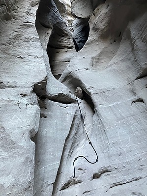
The loosest slots in Mecca Hills! by John10s Rope Canyon Trail is located in the Mecca Hills Wilderness, north of the Salton Sea and northeast of the community of Mecca, California. Starting from Painted Canyon Trailhead, Rope Canyon Trail quickly branches off the popular route for Ladder Canyon Trail and follows a slot canyon with a series of ropes to help hikers climb up the steeper obstacles. The route described here ascends and eventually exits the slot canyon, then drops back down to connect with Ladder Canyon. Most people will find it easier to go up the ropes than down, as spotting the footholds is easier from below. Hike The five-mile drive to the trailhead along Painted Canyon road is well-graded and suitable for passenger cars, passing plenty of interesting geology along the San Andreas Fault and ending at Painted Canyon Trailhead. A sign there includes a trail map of the area, but the lack of signage in the canyon and the multitude of side canyons limit the map's usefulness. There are no official signs marking any of the routes; the closest thing to signs you'll see are occasional spray-painted arrows on rocks.
Before reaching the first rope, you'll encounter a few obstacles that require scrambling up and over rocks or crawling under large boulders wedged between the canyon walls. The first two ropes are located back-to-back and lead through a tight, vertical slot ~20 feet high. Here, too, it's easier to squeeze through without a backpack. After this, the walls widen, and the canyon remains relatively flat for the next stretch. There are two more ropes to navigate, but the climbs are only a few feet high, and the ropes are more convenient than necessary. The canyon narrows again, and you'll have to duck under another boulder lodged between the walls before reaching another rope at a vertical wall ~20 feet high. This final rope is the tallest in the canyon, but the wall has a lot of recessions that provide good footholds. Once you've cleared this final rope, follow the open wash for roughly a third of a mile. The route becomes less obvious as the wash forks, but bear right (east) to leave the wash and pick up a social trail that continues along a ridge for another tenth of a mile and then drops back down to connect with Ladder Canyon. Here, you'll see a spray painted rock with the word "Rope" and an arrow pointing to the route you've just traversed. To return to the trailhead, you can either turn around and follow the same route back through Rope Canyon, which will require going down the five ropes, or continue exploring Ladder Canyon. Turning left (north) at the intersection will take you farther from the trailhead and require a longer loop back, while turning right (south) loops back more directly toward the trailhead through several narrow slots and ladders. Check out the Official Route and Triplog. Leave No Trace and +Add a Triplog after your hike to support this local community. One-Way Notice This hike is listed as One-Way. When hiking several trails on a single "hike", log it with a generic name that describes the hike. Then link the trails traveled, check out the example. | ||||||||||||||||||||||||||||||||||||||||||||||||||||||||||||||||||||||||||||||||||


