There are three trails on the trail map at the parking lot near the visitor center at the Schulman Grove. The Cabin Trail is a 2.8-mile hike. The trailhead is adjacent to the pit toilets near the visitor center. The route is a counterclockwise irregular loop that begins at the 10,076-foot elevation. After a short climb, the trail is relatively flat for the next ¾ of a mile.
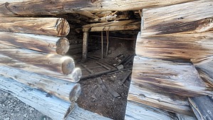
Near the end of the flat section, there are two cabin ruins and some mining remains. According to my topo map, the mine is called the Mexican Mine. After you pass the cabins, the trail begins to climb and tops out at 10,365 feet. The trail crosses a ridgeling and descends several switchbacks to the junction with the Methuselah Trail, at 10,096 feet.
To complete the loop, go left onto the Methuselah Trail. The trail heads back uphill from here to the 10,222-foot elevation, where the trail crosses a ridgeline. The trail then descends to the canyon floor at an elevation of 10,047 feet. The remaining tenth of a mile takes you to the visitor center and a final elevation of 10,079 feet.
WARNING! Hiking and outdoor related sports can be dangerous. Be responsible and prepare for the trip. Study the area you are entering and plan accordingly. Dress for the current and unexpected weather changes. Take plenty of water. Never go alone. Make an itinerary with your plan(s), route(s), destination(s) and expected return time. Give your itinerary to trusted family and/or friends.
To hike From Highway 395, head east on Highway 168 for about 13 miles. Turn left on White Mountain Road. In a little over 10 miles, you will reach the Schulman Grove turnout to the visitor center. Turn right and park. From Highway 266, head southwest on Highway 168 for about 25 miles and turn right on White Mountain Rd. Some signs state that you are entering a fee area. It’s cheap at $3 per person, payable at the visitor center. The cost is half price if you are 62 or older and have a lifetime national park pass.
 Route Editor