Route Editor

| Guide | ♦ | 1 Triplog | 0 Topics |
details | drive | permit | forecast | route |
stats |
photos | triplog | topics | location |
| 33 | 1 | 0 |
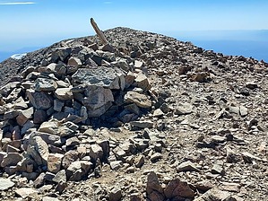
west trumps east by DixieFlyer West Spanish Peak (elevation of 13,583 feet and prominence of 3,623 feet) is the highpoint of Las Animas County. West Spanish Peak and its nearby sibling, East Spanish Peak (elevation of 12,680 feet), comprise the famed Spanish Peaks. These two peaks rise several thousand feet above the high plains of Colorado, and are prominent landmarks that can be seen for miles around. The Spanish Peaks were designated as a National Natural Landmark in 1976 and as a National Wilderness Area in 2018. As such, wilderness regulations apply when visiting the Spanish Peaks.
The Spanish Peaks are geologically distinct from the faulted and uplifted mountains of the Sangre de Cristo range to the west. The Spanish Peaks are prime examples of stocks, which are large masses of igneous rock layered by sedimentary rock and exposed by erosion. Among the most unusual features of the Spanish Peaks are the great dikes radiating out from the mountains like spokes of a wheel. There is a system of radial dikes that are centered on West Spanish Peak, which can be seen from the West Spanish Peak summit off to the north. Source: USDA Forest Service Hike The hike starts and ends at the West Peak Trailhead at an elevation of about 11,250 feet. The hike begins by taking the West Peak Trail #1390 for 2.8 miles from the trailhead to the tree line at about 12,000 feet. This trail is well-marked, well-maintained, and a joy to hike on. The elevation at the one-mile mark is about the same as the trailhead elevation, although there is a bit of up-and-down during this segment. Thereafter, you'll gain some elevation up to the tree line, but the slopes are gentle and there are switchbacks in all the right places. Things change once the trail ends at the tree line. From that point it is 0.9 miles to the summit, gaining about 1,600 feet up steep, slippery talus slopes. However, there is a decent use trail up through the talus, along with some cairns that will help keep you on track. The use trail is mostly easy to follow, but it is still a good idea to have a GPS track in your back pocket. This portion of the hike is slow-going, but if you take a section at a time you'll make it up to the summit. There are great views at the summit, especially of the Sangre de Cristo range to the west. After taking a break and enjoying the views, return to the trailhead the way that you came. Warning Like most high-elevation Colorado peaks, there is often a risk of afternoon thunderstorms. It is generally best to start early so as to be back below the treeline before any such storms begin. Check out the Official Route and Triplog. Note This is a moderately difficult hike. Leave No Trace and +Add a Triplog after your hike to support this local community. | |||||||||||||||||||||||||||||||||||||||||||||||||||||||||||||||||||||||||||||||||||||||||||||