Hiking this trail during our great December weather, we figured the trail would be crowded. We were pleasantly surprised to find nothing but peace and quiet. The Sunday we hiked it, we saw only six hikers all day long. Impressive on a hike so close to town.
Beginning from the San Juan trailhead, hikers should be ready for a few switchbacks and some serious elevation gain, over 1100', in the first mile or so. It's easy to forget about the elevation change with the great views to the north, west, and south. We had a clear winter day and watched the morning sun race across the valley and light up the Estrella Mountains from Maricopa to Goodyear. The trail sticks almost exclusively to the north face of the ridge. The morning light's shrinking shadows made it chilly for us but would make for a great cool morning hike in late spring or early fall. The hike's high point comes quickly and offers excellent views of the west valley all the way out to the steam plume of the Palo Verde nuclear plant. After another half mile or so at a lower elevation on the north face, the trail climbs back to the ridgeline. From this vantage point, the trail offers a wonderful perspective view. Phoenix's encroaching development on the north contrasts sharply with the great expanse to the south of the undisturbed wilderness of South Mountain Park. Leaving the ridge and turning south, more switchbacks bring you easily to the valley floor and the east end of the Bajada trailhead.
Following the Bajada Trail, we connected with a portion of the National Trail, which brought us back to the San Juan parking lot. Except for the first mile, this is an easy hike in quiet country with some beautiful views. The only distracting things were the sporadic gunshots we heard from the Police Academy and the occasional jet overhead.
When hiking several trails on a single "hike", log it with a generic name that describes the hike. Then link the trails traveled, check out the example.
WARNING! Hiking and outdoor related sports can be dangerous. Be responsible and prepare for the trip. Study the area you are entering and plan accordingly. Dress for the current and unexpected weather changes. Take plenty of water. Never go alone. Make an itinerary with your plan(s), route(s), destination(s) and expected return time. Give your itinerary to trusted family and/or friends.
Permit $$
None
Directions
Road
Paved - Car Okay
To Alta Trailhead From Phoenix, head straight down Central Avenue. Keep going and going until it hits South Mountain where the road curves west passing an entrance gate. Stop at the information center and pick up a groovy free map. Last chance for restrooms and water. There is a cold water fountain and soda machines. If you can't find a map just keep on following the road. Continue two miles out and turn right onto San Juan Road. Take San Juan Road to the very end, about three miles. The trailhead is clearly marked on the East side of the parking lot.
San Juan Road is open to vehicles the first full weekend of every month for easy access to the Alta, Bajada and National trails. The road is closed to motor vehicles all other times.
From PHX (I-10 & AZ-51) 15.8 mi, 33 mins From TUC (Jct 1-10 & Grant) 115 mi, 1 hour 54 mins From FLG (Jct I-17 & I-40) 155 mi, 2 hours 31 mins
 Route Editor

 Hiking this trail during our great December weather, we figured the trail would be crowded. We were pleasantly surprised to find nothing but peace and quiet. The Sunday we hiked it, we saw only six hikers all day long. Impressive on a hike so close to town.
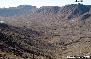


