 Route Editor

| Guide | ♦ | 1 Triplog | 0 Topics |
details | drive | permit | forecast | route |
stats |
photos | triplog | topics | location |
| 27 | 1 | 0 |
if you slip in the mud, own it by LindaAnn Hike The parking area has room for about 6-8 vehicles, several notices warning you about bears (black & grizzly) and the start of the trail is well signed and leads immediately down to McCormick Creek. Depending on the flow of the creek, the first 100' of the hike may be the most challenging part of the day. If you want dry shoes for the entirety of the hike, take them off here and cross barefoot. Carefully cross the creek (a pole is recommended) and pick up the trail on the other side.
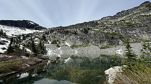
At about 3.25 miles, you'll cross Gunsight Creek. The creek is basically a granite cascade, and is quite impressive. You should be able to keep your feet dry if you're careful. As you're now heading southwest, you'll cross a couple more small creeks (all easy) and the views ahead of you continue to improve. The first 5 miles of this trail are in good shape with a consistent incline of about 400' per mile. At around mile 5, the trail condition deteriorates and becomes rockier and notably steeper, gaining about 800' in the final mile up to the lake. Luckily, the views improve dramatically at this point. The Selkirks are glacier-carved granite, and the bare rock along the crest beckons for exploration. A very pointy Hunt Peak looms ahead. A few well-placed cairns keep you on track through the sections of bare rock, but if you get off course, head straight west, keeping the creek to your right. The last 200' of gain to the lake is probably the steepest of the trail, but at this point, you know you're close. There are several places to camp along the edge of the lake, and a bear box is available for food storage. Snow lingers well into summer. The lake sits in a cirque, surrounded by steep granite on three sides. The small "peak" immediately north of the lake allows for some easy (or hard) scrambling around with views of the lake from above. Note: Stats listed are one-way, and out and back is 12 miles total. A pole is recommended for the water crossings. Waterproof shoes are very helpful due to the mud and running water on much of the trail. Snow melt early in the summer can add to the creek crossing challenge. Be aware of grizzlies and moose. There is occasional cell reception, but it is light, don't count on it. Check out the Official Route and Triplog. Leave No Trace and +Add a Triplog after your hike to support this local community. One-Way Notice This hike is listed as One-Way. When hiking several trails on a single "hike", log it with a generic name that describes the hike. Then link the trails traveled, check out the example. | |||||||||||||||||||||||||||||||||||||||||||||||||||||||||||||||||||||||||||||||||||||


