Route Editor

| Guide | ♦ | 2 Triplogs | 0 Topics |
details | drive | permit | forecast | route |
stats |
photos | triplogs | topics | location |
| 23 | 2 | 0 |
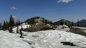
amazing 360-degree view by LindaAnn Hike: Starting at the Big Fisher Lake TH near the end of Trout Creek road, head north on Pyramid Pass Trail #13. There is a brown message board at the start of the trail, but it doesn't actually mention the names of the trails that start from this spot.
At the next marked trail junction, at about 1.25 miles, stay on the left fork (sharp left) to continue on Pyramid Pass. The right fork takes you to Trout Lake and Big Fisher Lake. After this point, the views start to open up the higher you climb. Once over Pyramid Pass, the trail descends about 300' off the north side of the pass. Snow lingers well into summer in this area. The next marked junction, which is the end of Pyramid Pass Trail, is a little confusing. There is a sign on a tree as you begin hiking north on Parker Ridge Trail #221, but no trail junction. Walk another 20-30' and you will see another sign (Pyramid Trail #7) at a left fork, but no sign indicating the right fork. The right fork is the Parker Ridge Trail, continue on this which begins climbing more steeply uphill. As you continue to head north, great views open up to the west, and then to the east as you climb. Long Mountain becomes visible to your north. The trail continues up the south ridge of aptly named Long Mountain, winding among the granite boulders. There are a couple of false summits as you gently climb the ridge, and again, this area holds snow well into summer. Long Mountain Lake is visible below you to the east. At about 3.60 miles, there is a good side trail leading down to the lake; the junction is unmarked but quite obvious. Just before reaching the summit, while you are still directly south of the summit, the trail veers slightly to the west and just below the actual summit. At this point, leave the trail and continue on the south ridge. The off-trail is incredibly easy as you pick the path of least resistance. There's no guesswork to this one, the high point is quite obvious, a large boulder with room to sit on it. Enjoy the amazing 360-degree views as you rest. Once done, retracing your steps back downhill is quite easy. Once back on the trail, you'll notice more loose rock than you did on the ascent, but the trail is in generally good shape. The only mildly challenging part of your return is the 300' climb back over Pyramid Pass. Note: This is bear and moose country, be aware of your surroundings, especially if backpacking. The only cell service along this route seems to be at the summit of Long Mountain and might be a Canadian carrier. Don't be shocked if you get hit with roaming charges based on your plan. Check out the Official Route and Triplogs. Leave No Trace and +Add a Triplog after your hike to support this local community. | |||||||||||||||||||||||||||||||||||||||||||||||||||||||||||||||||||||||||||||||||||||