 Route Editor

| Guide | ♦ | 3 Triplogs | 0 Topics |
details | drive | no permit | forecast | route |
stats |
photos | triplogs | topics | location |
| 98 | 3 | 0 |
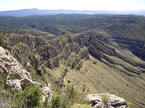
It's all about the End... by imike  Immediately off the ridge, a hogback formation curves off and down into the drainage with impressive erosive spires, leading over to huge shiprock mesa formations projecting out towards the basin far below. The drainage winds down to the desert floor, ending in a section of the White Sands National Monument (not sure why... there is no white sand over here). Off and across the basin lies the southern end of the vast White Sands Desert... sprawling away into the distance and over to the mountains on their far side. It is a spot to linger and enjoy the spectacle.
Check out the Official Route and Triplogs. Leave No Trace and +Add a Triplog after your hike to support this local community. One-Way Notice This hike is listed as One-Way. When hiking several trails on a single "hike", log it with a generic name that describes the hike. Then link the trails traveled, check out the example. | |||||||||||||||||||||||||||||||||||||||||||||||||||||||||||||||||||||||||||||||||||||||||||||||


