Route Editor

| Guide | ♦ | 3 Triplogs | 0 Topics |
details | drive | permit | forecast | route |
stats |
photos | triplogs | topics | location |
| 22 | 3 | 0 |
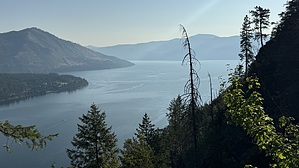
relentless moment after a pleasant lollygag by LindaAnn Hike: Starting from the trailhead at the end of Twete Rd, head directly east on the dirt road. There is a sign at the start informing you that you are traveling on private property and to stay on the marked path. As you walk east, Bernard Peak is visible directly in front of you. The road heads straight east for about a third of a mile, then curves to the northeast as it gently climbs. Signs inform you this is Scout Trail.
Assuming you take the left fork, the trail drops slightly as you head north. Before too long, you'll reach a sign with a trail connecting from the left. This trail is the connector from nearby Farragut State Park, where taking the High Point Trail, then the connector, also brings you to this point, but is a longer hike by about a mile. After that junction, there will be another signed junction. Head north to the best viewpoint of Lake Pend O'Reille, which has a bench and interpretive sign. It's an almost vertical drop down to the lake more than 800' below you. Retrace your steps back to the junction, then head east to continue on Scout Trail. Heading east, two trails generally parallel each other, intertwining at times. One has slightly better views of the lake, but poor footing in places. Take whichever trail you'd prefer. At about 2.50 miles, you'll reach a junction with three signs--two for the Scout Trail system, which you were just on, and one sign pointing you east, for Bernard Peak (trail 37). Once on Bernard Peak Trail, the route finding is easy. The trail is in good shape as you head east and steadily climb the north slope of Bernard. Some of this area has lightly burned in recent years, allowing for some views through the leafless/needleless? trees, but most of the trail has plenty of green and is limited on distant views. The incline is never steep and the hiking is quite enjoyable. Long switchbacks take you uphill before traversing around the west side of the mountain. Eventually, the trail takes a sharp turn to the north and continues uphill reaching a forest road. The trail picks up again about 30' up the road on the right-hand side. You are just below the summit, and this final short section of trail is the steepest of the hike. Luckily, it's over in a moment as you reach the summit. The top is clear and is obviously used for camping, with a campfire ring in the center of the dirt clearing, and plenty of room for several tents and vehicles. There is a rocky high point just to the south of the dirt clearing, and another high point with the footings of an old fire tower just to the north of the clearing. Trees all around the clearing block any views. Once done up top, retrace your steps back downhill. The good trail conditions make for a fast and easy descent. Once you reach the Scout Trail system again, if you already looked at the lake on the way uphill, stay on the route marked "Twete Road Easy Escape" for a smoother descent. The road walk for the final couple of miles goes by quickly. Check out the Official Route and Triplogs. Leave No Trace and +Add a Triplog after your hike to support this local community. | |||||||||||||||||||||||||||||||||||||||||||||||||||||||||||||||||||||||||||||||||||||