 Route Editor

| Guide | ♦ | 2 Triplogs | 0 Topics |
details | drive | no permit | forecast | route |
stats |
photos | triplogs | topics | location |
| 13 | 2 | 0 |
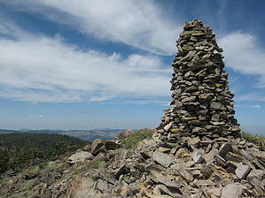
Wally And The Beaver by AZLOT69 Hike: A well marked trailhead designates the start of this interesting hike. Don't let the mileage fool you. Its short but adds elevation gain to a sometimes faint trail to make it very interesting. There are some areas which hold snow pack practically year round and this requires some skill in staying with the trail. Don't expect to see anyone else as this is off the beaten path. The trail starts off in old growth forest and passes thru several small meadows and across a creek. Ferns and wildflowers line the smooth trail for a time. The trail gets steeper and serpentines to lessen the grade. From a northerly direction the trail makes a dramatic turn to the northeast and up to a saddle. An abrupt turn to the west brings you within sight of a talus covered knoll. This is one of several false peaks. There are fewer trees now and one of the first distant views is Sierra Buttes to the southwest. Continuing on you will see several more knolls. The knoll appearing on the right side of the trail thru the tree cover is your destination. It is distinguished by what appears to be a stone chimney on top. This cairn has been built by various visitors over the years. The trail now becomes rock talus up to the peak. There is no exposure or cliffs to worry about and most can make it to the peak by choosing the easiest route. The views offered at the top include Mt. Lassen, Sierra Buttes, Mt. Elwell and Eureka Peak. Before heading down, check out some of the other rocky knolls for more great views. When finished return the way you came. Check out the Official Route and Triplogs. Leave No Trace and +Add a Triplog after your hike to support this local community. One-Way Notice This hike is listed as One-Way. When hiking several trails on a single "hike", log it with a generic name that describes the hike. Then link the trails traveled, check out the example. | ||||||||||||||||||||||||||||||||||||||||||||||||||||||||||||||||||||||||||||||||||||||||||||


