username
X
password
register
for free!
help
  This is likely a great time to hike this trail!  Check out "Preferred" months below, keep in mind this is an estimate.
  

Mosquito Falls - Pictured Rocks Nat. Lakeshore, MI

Guide 1 Triplog  0 Topics
  3 of 5  
Fav
Wish
0
details
drive
permit
forecast
route  
stats
photos
triplog
topics
location
6 1 0
Statistics
tap row or icons for details
Difficulty 2.5 of 5
Route Finding 1 of 5
Distance Round Trip 2.6 miles
Trailhead Elevation 755 feet
Elevation Gain 1 feet
Accumulated Gain 285 feet
Avg Time Round Trip 1:15 hours
Kokopelli Seeds 4.03
 Interest Perennial Waterfall & Perennial Creek
unreported if dogs are allowed
editedit > ops > dogs to adjust
feature photo
Photos Viewed All MineFollowing
6  2024-08-12 The_Eagle
Author
author avatar Guides 41
Routes 1,626
Photos 14,983
Trips 2,760 map ( 18,597 miles )
Age 69 Male Gender
Location Far NE Phoenix, Az
Historical Weather
Trailhead Forecast
Radar Map
Expand Map
Preferred Sep, May, Jun, Aug → 7 AM
Sun  6:09am - 7:20pm
Official Route & 1 Rt
 
0 Alternative


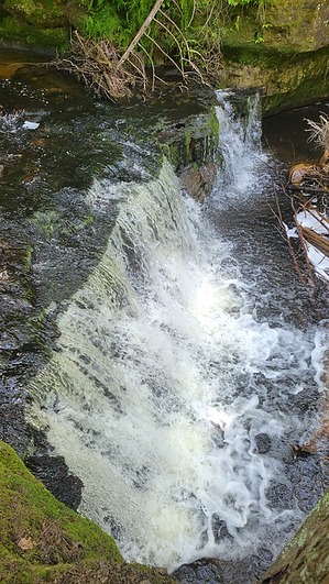
Chasing Waterfalls and Dodging Mosquitoes
by The_Eagle

  Likely In-Season!
Warning,
When wet, this hike can be muddy and slippery with exposed roots.


Numerous hiking options are available from this TH.
remove free decal offer
The hike from Chapel Falls TH to Mosquito Falls in Pictured Rocks National Lakeshore is a great way to explore Michigan’s Upper Peninsula. This trail is about a 2.6-mile round trip and takes you through a beautiful forest filled with tall trees like maple, birch, and hemlock. Deer, squirrels, or even a black bear can be seen. Keep an eye out for birds, woodpeckers and warblers are common in this area.

The trail follows Mosquito River, leading you to the scenic Mosquito Falls. The falls aren’t huge, but they are surrounded by rocks covered in green moss and ferns, making it a peaceful and pretty resting spot. The name “Mosquito Falls” comes from the early settlers who dealt with a lot of mosquitoes in the area, which is something to be prepared for during your hike. We did not see/feel any during our mid-August hike

Pictured Rocks National Lakeshore, where this hike is located, was created in 1966 to protect the area's natural beauty, including its famous sandstone cliffs. This hike gives you a chance to enjoy the park's quiet forests, see some wildlife, and experience the beauty of the waterfalls up close.

2024-08-22 The_Eagle


    Check out the Official Route and Triplog.
    Leave No Trace and +Add a Triplog after your hike to support this local community.
    WARNING! Hiking and outdoor related sports can be dangerous. Be responsible and prepare for the trip. Study the area you are entering and plan accordingly. Dress for the current and unexpected weather changes. Take plenty of water. Never go alone. Make an itinerary with your plan(s), route(s), destination(s) and expected return time. Give your itinerary to trusted family and/or friends.

     Permit $$
    Special Use

    Special
    2024 entrance:
    Standard Pass Walk-in $15.00–$25.00 Vehicle
    Annual Pass $45.00
    America the Beautiful Pass (includes Senior Passes) FREE–$80.00


     Directions
    or
     Road
    Paved - Car Okay

    To hike
    Head east out of Munising on Adams Trail to Chapel Road. The turn is well-signed. This is a popular TH. Be prepared to walk extra to the TH.
    page created by The_Eagle on Aug 22 2024 3:57 pm
     90+° 8am - 6pm kills
    helpcorrectionissue

    end of page marker