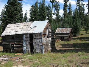
History: John Kelly had four claims in an area roughly eighty acres on this lava capped ridge. Gold was the object of his search. He employed five men and built a small camp at this location. What remains are two standing cabins and an old miners gravesite. This is the Sawpit Flat Mining District.
Overview: The hike is a combination of old logging roads and bushwhacking the steep canyons. The loop taken includes views of Mohawk Gap, Mohawk Valley, Woodchuck Mine, and the Hayes Mine.
Hike: Starting on the old unmarked logging road in an easterly direction the cabins appear in about a third of a mile. Both were standing as of this writing and were in pretty good shape. The cabin to the east is two stories tall with a single room on each floor. A steep and not very stable staircase leads to the second floor. The cabin to the west is also two floors but the upper floor has collapsed. It has obviously had an addition to the rear of the cabin as the building material is different. The metal roofs are intact but occasionally blow up and slam down in the wind which can catch you off guard. Especially if the first time it happens is when you are examining the gravesite to the south of the cabins. From here Mohawk Gap lies to the north. Bushwhacking in that direction is easy enough until you come to a ridge. Work your way thru the vegetation into the ravine. The ravine drops at a steep rate with loose footing. It is in these steep ravines that the miners employed hydraulic mining techniques to move the rock and soil in their pursuit of gold. Negotiating the loose soil and rocks can make for slow going. The scars of this mining is obvious the further down the ravine you go. This was the Hayes mining claim. Continue by working yourself up and over the ravine on the opposite side. The hillside is steep as you go into another ravine. Pass thru this one on the way to the next. Tailings abound as you approach the Woodchuck mining claim. This is a much bigger ravine in which the spring water runoff appears to be substantial. The scars on the land are deep and are indicative of the hard work these individuals endured. To the north lies Mohawk Valley 2,500 feet below. There is an occasional view thru the trees. Work your way up this ravine back to the old logging road. From here go to the right to return to the miners cabins and ultimately your vehicle.
WARNING! Hiking and outdoor related sports can be dangerous. Be responsible and prepare for the trip. Study the area you are entering and plan accordingly. Dress for the current and unexpected weather changes. Take plenty of water. Never go alone. Make an itinerary with your plan(s), route(s), destination(s) and expected return time. Give your itinerary to trusted family and/or friends.
Permit $$
None
Directions
Road
FR / Jeep Road - Car possible when dry
To hike From Graeagle drive south on Hwy 89 for 1.4 miles. Turn south on Gold Lake Highway. After 8.7 miles turn left on Church Creek Road. Proceed past any turnoffs for 1.2 miles to FS 28. Continue 1.3 miles on FS 28. Turn left at next road(there is a sign but the numbers are gone). Drive one third mile and park.
 Route Editor