The hike from the Hurricane Creek Trailhead to the Au Sable Light Station in Michigan’s Upper Peninsula offers a blend of beautiful scenery and shipping history. This 3-mile round-trip hike takes you through dense forests and along the rugged shoreline of Lake Superior, leading to one of the most iconic landmarks in the area. The trail is flat and smooth.
This TH also offers easy access to the North Country Trail NCT). This is the longest National Scenic Trail in America, stretching 4,800 miles across eight states from North Dakota to New York.
Starting at the Hurricane Creek Trailhead, the trail winds through a mix of pine and hardwood forests. The wind rustling through the trees and the crash of waves sets the tone for the hike. The aqua color reminds you of the Caribbean. The path eventually brings you to the Au Sable Light Station, sitting on a bluff overlooking Lake Superior.
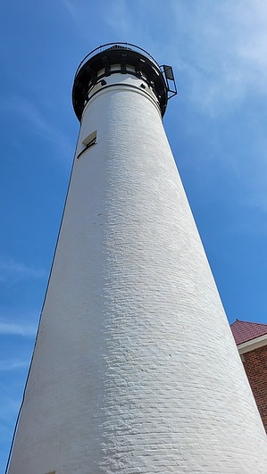
Built in 1874, the Au Sable Lighthouse was crucial for guiding ships along the dangerous "Graveyard Coast," a stretch of shoreline notorious for shipwrecks. The unpredictable weather and hidden reefs in this area claimed many ships over the years. Several shipwrecks can still be found near the lighthouse, their remains visible from the shore on clear days. The lighthouse’s powerful beam and fog signal were vital in preventing further disasters, helping countless ships navigate the treacherous waters.
WARNING! Hiking and outdoor related sports can be dangerous. Be responsible and prepare for the trip. Study the area you are entering and plan accordingly. Dress for the current and unexpected weather changes. Take plenty of water. Never go alone. Make an itinerary with your plan(s), route(s), destination(s) and expected return time. Give your itinerary to trusted family and/or friends.
Permit $$
None
Directions
Road
Paved - Car Okay
To hike From Munising take Adams Trail, East, to Au Sable Light Trail. The signage is plentiful to the TH.
 Route Editor