Route Editor

| Guide | ♦ | 1 Triplog | 0 Topics |
details | drive | no permit | forecast | route |
stats |
photos | triplog | topics | location |
| 9 | 1 | 0 |
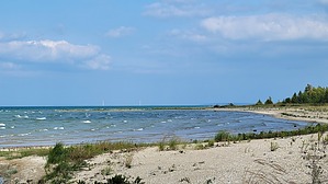
Shore Thing by The_Eagle  The trail starts at the Waugoshance Point parking area and follows the shoreline all the way to the point. Since you’re walking on a beach, the trail is mostly sandy and gravelly, which can be tiring to walk on.
As you reach the end of the trail, you’ll be rewarded with stunning views of Lake Michigan, the Upper Peninsula, and the Mackinac Bridge. The peaceful shoreline is a perfect spot to relax and take in the beauty of Wilderness State Park. Return the way you came. This hike is perfect for those who love nature, history, and a bit of adventure. Check out the Official Route and Triplog. Leave No Trace and +Add a Triplog after your hike to support this local community. | ||||||||||||||||||||||||||||||||||||||||||||||||||||||||||||||||||||||