 Route Editor

| Guide | ♦ | 12 Triplogs | 0 Topics |
details | drive | no permit | forecast | route |
stats |
photos | triplogs | topics | location |
| 5 | 12 | 0 |
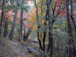
Up, Down and Around... by imike The Rim trail generally follows the upper ridgeline of the Sacramento mountains, between 8500' and 9500', which also closely follows the roadway for the Scenic drive of Sunspot Hiway (NM6563). This means that often the trail is not far from the road (100'), which provides numerous opportunities to access or exit the trail. This is a nice feature, especially for mountain bike riders who tire of the up/down, often deadfall obscured trail... they can always opt for the paved road.
I find the best use for this portion of the Rim trail is as a connector... creating loops with the various trails dropping down from the rim in the numerous drainages, particularly trail #109 (Alamo Canyon) connecting to either Atkinson Canyon trail (#111) or Pipeline trail (#110)... driving out to access the trail at either Karr, Alamo or Ackinson Canyon roads. Some folks enjoy the mountain biking on this hilly portion. The difficulty noted is for the accumulated elevation gain for the full-length hike... probably averaging only 150' to 200' per mile, but it adds up over that much mileage. If you are staying in Cloudcroft and desire a nice, longer outing, T105 may be accessed directly from the Village by making your way to the end of Curlew Place, then to the dead-end of Corona (past the Gray Townhomes)... the trail will take you out NM 130, cutting through a tunnel underpass, then within a mile connecting with the old formal trailhead for the National Rec trail... very nice access for the mountain biking from town. Trail #105 extends well beyond the terminus of the National Recreation Trail section. Still, it is best broken down into this portion, typically called the upper trail... and the section of trail that includes the Solar Observatory at Sunspot and beyond... normally considered the lower section... You will also note if you drive along the Sunspot Hiway (NM6563), various gate accesses provide parking and entry to the trail. Pick your spot and enjoy the scenery. Though, for the most part, overgrown and closed in, there are a few long views down to the Tularosa Basin and the broad expanse of white sand down in the Monument. Often, you would need to leave the trail and hike a few hundred feet or yards to see beyond the dense tree cover. It is a nice trail... no a great trail. Does have the advantage of very little use. You will likely have it all to yourself! Gate Policy: If a gate is closed upon arrival, leave it closed after you go through. If it is open, leave it open. Leaving a closed gate open may put cattle in danger. Closing an open gate may cut them off from water. Please be respectful, leave gates as found. The exception is signage on the gate directing you otherwise. Check out the Official Route and Triplogs. Leave No Trace and +Add a Triplog after your hike to support this local community. One-Way Notice This hike is listed as One-Way. When hiking several trails on a single "hike", log it with a generic name that describes the hike. Then link the trails traveled, check out the example. | |||||||||||||||||||||||||||||||||||||||||||||||||||||||||||||||||||||||||||||||||||||||||||||||


