Route Editor

| Guide | ♦ | 1 Triplog | 0 Topics |
details | drive | no permit | forecast | route |
stats |
photos | triplog | topics | location |
| 15 | 1 | 0 |
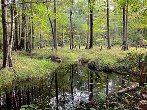
I'm younger than that now by kingsnake  Trails in both units are clearly shown on US Topo and consist mostly of old, sandy, jeep trail. There are many more old roads than official trails. Some of those roads are private property, so stay on official trails. More info @ NC Parks.
Features Rockefeller House and Mill Pond, which are on the National Register of Historic Places. Fishing is allowed in the pond: no swimming or boating. There are two trails: Rockefeller Loop Trail (2.1 mi.) and Cypress Point Loop Trail (0.4 mi.). Sand Hills Access The trailhead has room for horse trailers. Fishing is allowed. Rest benches and picnic tables are scattered along the trails. Junctions are signed with direction & distance. It has no history, per se, but more trails to explore: Wire Grass Loop: 1.4 mi., blazed by blue hexagon. Accessible from trailhead. Longleaf Pine Trail: 4.0 mi., blazed by white triangle. Accessible from trailhead. Provides access to the following trails: Little Pond Spur: 0.1 mi., blazed by blue triangle. Fox Squirrel Loop: 1.1 mi., blazed by yellow hexagon. Dead End Spur: 0.6 mi., blazed by yellow triangle. RCW Loop: 1.5 mi., blazed by orange hexagon. Turkey Oak Loop: 1.7 mi., blazed by white hexagon.
Check out the Official Route and Triplog. Leave No Trace and +Add a Triplog after your hike to support this local community. | ||||||||||||||||||||||||||||||||||||||||||||||||||||||||||||||||||||||||||||||||