username
X
password
register
for free!
help
 This is likely a great time to hike this trail!  Check out "Preferred" months below, keep in mind this is an estimate.
  

Q'emiln Park - Purple Circle Trail, ID

Guide 1 Triplog  0 Topics
  5 of 5  
Fav
Wish
0
details
drive
permit
forecast
route  
stats
photos
triplog
topics
location
30 1 0
Statistics
tap row or icons for details
Difficulty 2 of 5
Route Finding 1 of 5
Distance One Way 3.23 miles
Trailhead Elevation 2,160 feet
Elevation Gain 292 feet
Accumulated Gain 639 feet
Avg Time One Way 2 hours
Kokopelli Seeds 5.36
 Interest Perennial Creek
 Backpack No
feature photo
Photos Viewed All MineFollowing
30  2024-10-11 LindaAnn
Author
author avatar Guides 110
Routes 2,246
Photos 8,982
Trips 2,600 map ( 15,998 miles )
Age 45 Female Gender
Location Ahwatukee, AZ
Historical Weather
Trailhead Forecast
Radar Map
Expand Map
Preferred Jun, Jul, Aug, Sep
Seasons   ALL
Sun  6:11am - 7:21pm
Official Route & 1 Rt
 
0 Alternative


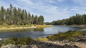
Daylight come, ka-mee-lin is a glow
by LindaAnn

 Likely In-Season!
Overview: Q'emiln Park and the Post Falls Community Forest share a small network of trails along the south side of the Spokane River. All the trails are well-marked, and it is easy to create numerous loop options within the trail system. The area is also popular for rock climbing, fishing, and water recreation.


Hike: The Purple Circle trail can be accessed from trailheads at either end of the trail--Q'emiln (pronounced ka-mee-lin) Park at the east end, or Post Falls Community Forest at the west end. This guide is written from east to west, starting from Q'emiln. The trail begins at the northwest corner of the parking lot, and is marked with purple circles every few hundred feet. Some markers are on posts, and others are fastened to trees, but they are generally easy to spot. The trail starts off following a black chain link fence, and the south fork of the Spokane River is below you. The south dam is also clearly visible as you hike past it.
remove free decal offer
At about 0.10 miles, there is a side trail leading down towards the river, and a bolted climbing wall. Checking this area out is worth the short side trip. The main trail is the left fork and is signed with the ever-present purple circles. The trail winds through the rocks and seems to end at a rock outcropping--curve left around these rocks, using caution on the edge, and follow the trail south towards another large climbing wall. At the wall, the trail crosses a bridge, continues south for a short distance, then turn right and heads towards the northwest. As you approach the river, the trail makes a series of steep climbs and drops before finally leveling off just above the water.

The next 1.50 miles or so is easy hiking, generally paralleling the south bank of the Spokane River. There are numerous places to leave the main trail and walk down to the water. The powerhouse is clearly visible across the river. And you'll pass the remnants of an old tower of some sort at the edge of the water. Later, you'll pass what's left of a cable car platform. All junctions with other trails are clearly marked.

At about 2.25 miles, the trail leaves the edge of the river and turns uphill, first following an old dirt road, then on asphalt. The paved road is the access for some private properties that border the west edge of the park, so there is occasional traffic on the road. Luckily, you are only on the road for less than half a mile before turning east on a regular trail. The trail gently climbs uphill to the Community Forest trailhead. From here, you can retrace your steps back to your origin point, or make a loop utilizing the other trails within the system.

Note: Dogs are allowed on the trails (leashed), but not in the rest of Q'emiln Park.

2024-10-11 LindaAnn


    Check out the Official Route and Triplog.
    Leave No Trace and +Add a Triplog after your hike to support this local community.

    One-Way Notice
    This hike is listed as One-Way.

    When hiking several trails on a single "hike", log it with a generic name that describes the hike. Then link the trails traveled, check out the example.
    WARNING! Hiking and outdoor related sports can be dangerous. Be responsible and prepare for the trip. Study the area you are entering and plan accordingly. Dress for the current and unexpected weather changes. Take plenty of water. Never go alone. Make an itinerary with your plan(s), route(s), destination(s) and expected return time. Give your itinerary to trusted family and/or friends.

     Permit $$
    Information is listed below


     Directions
    or
     Road
    Paved - Car Okay

    To hike
    Q'emiln Park: From I-90 in Post Falls, take the Spokane St exit and head south. You'll cross the Spokane River, then the entrance to Q'emiln Park is the first right past the river. Note: there is a parking fee at Q'emiln between Memorial Day and Labor Day.

    Post Falls Community Forest trailhead: From I-90 in Post Falls, exit at Spokane St and head south, crossing the river. Continue south, and Spokane St will turn into Riverview Drive at a Y intersection, stay right and follow Riverview for about 1.50 miles to the trailhead on the right. There is no parking fee, but it is a much smaller parking lot.
    page created by LindaAnn on Oct 11 2024 6:09 pm
     90+° 8am - 6pm kills
    helpcorrectionissue

    end of page marker