username
X
password
register
for free!
help
 

Mesquite Spur - FHP, AZ

Guide 5 Triplogs  0 Topics
  2 of 5  
Fav
Wish
0
details
drive
no permit
forecast
route  
stats
photos
triplogs
topics
location
0 5 0
Statistics
tap row or icons for details
Difficulty 1.5 of 5
Route Finding 1 of 5
Distance One Way 0.14 miles
Trailhead Elevation 2,703 feet
Elevation Gain -22 feet
Accumulated Gain 37 feet
Avg Time One Way 4 minutes
Kokopelli Seeds 0.26
 Backpack No
feature photo
Photos Viewed All MineFollowing
14  2025-04-17
Sonoran / Lower Sonoran Lasso Loop - FHP
DixieFlyer
5  2025-04-13
Sonoran / Lower Sonoran Lasso Loop - FHP
DixieFlyer
4  2025-04-06
Sonoran / Lower Sonoran Lasso Loop - FHP
DixieFlyer
2  2025-03-10
Sonoran / Lower Sonoran Lasso Loop - FHP
DixieFlyer
Author
author avatar Guides 99
Routes 1,484
Photos 16,072
Trips 1,374 map ( 13,602 miles )
Age Male Gender
Location Fountain Hills, AZ
Historical Weather
Trailhead Forecast
Radar Map
Expand Map
Preferred Nov, Dec, Jan, Feb → 7 AM
Seasons   ALL
Sun  6:04am - 6:47pm
Official Route
 
4 Alternative


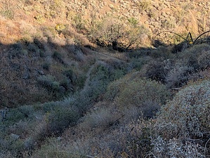
Watch out for mesquite-o's on this trail
by DixieFlyer

Overview
This is a short companion trail to the Mesquite Hollow Trail in the Fountain Hills Preserve (FHP).


Hike
To get to the Mesquite Spur from the Adero Canyon Trailhead, begin hiking on the Promenade Trail. After about 0.9 miles, you will come to a 4-way junction at the north end of the Promenade Trail. From there, go southwest and take the Mesquite Hollow Trail. In 0.45 miles, turn left at the sign for the Mesquite Spur. After being on the Mesquite Spur for 0.14 miles, you will be back on the Mesquite Hollow Trail.
remove free decal offer
At the junction, when you come back to the Mesquite Hollow Trail, you will be next to the large mesquite tree from which the Mesquite Hollow Trail derives its name. This is the only mesquite tree along the trail and one of the few mesquite trees in the FHP.

The Mesquite Spur has a couple of steep and rocky sections, so despite its short distance, it might be slightly difficult for beginning hikers.

2025-03-10 DixieFlyer
  • 2025 Map
    area related
    2025 Map


Check out the Official Route and Triplogs.
Leave No Trace and +Add a Triplog after your hike to support this local community.

One-Way Notice
This hike is listed as One-Way.

When hiking several trails on a single "hike", log it with a generic name that describes the hike. Then link the trails traveled, check out the example.
WARNING! Hiking and outdoor related sports can be dangerous. Be responsible and prepare for the trip. Study the area you are entering and plan accordingly. Dress for the current and unexpected weather changes. Take plenty of water. Never go alone. Make an itinerary with your plan(s), route(s), destination(s) and expected return time. Give your itinerary to trusted family and/or friends.

 Permit $$
None


 Directions
or
 Road
Paved - Car Okay

To Adero Canyon Trailhead
From Loop 101 and Shea Blvd head east on Shea Blvd for 7.8 miles. Then turn left on N Palisades Blvd and continue 1.1 miles. Turn left at the stop sign onto Eagle Ridge Drive and continue 2.4 miles until you reach the Adero Canyon Trailhead. Note that along the way Eagle Ridge Drive first becomes N 143rd Way and then becomes N Eagle Ridge Drive.

• February 2019: There is road construction on Eagle Ridge Dr, and the last mile to the trailhead is on a well-graded, unpaved road. However, that section of the road will ultimately be paved.
• January 2020 FHP writes: Fountain Hills (Parks & Wildlife Dept..480-816-5100): Adero Cyn TH/Parking is presently "only" accessible for parking access at the closed chain link fence ~1 mile "prior-to" TH Parking on N. Eagle Ridge Drive. M-F Trailhead access from ~1 mile up road is only legal from 3pm daily. Sat & Sun TH access from ~1 mile up road is legal from dawn to dusk.
• 2020-02-15 Yoder writes: Road to trailhead parking is closed due to construction. You may want to go to the Sunrise Trailhead parking.
• 2020-11-09 Grasshopper writes: Officially opened, and the road to the Parking / TH is now paved.


From PHX (I-10 & AZ-51) 43 min (32.3 miles)
From TUC (Jct 1-10 & Grant) 2 h 7 min (131 miles)
From FLG (Jct I-17 & I-40) 2 h 28 min (155 miles)
page created by DixieFlyer on Mar 10 2025 11:27 am
 90+° 8am - 6pm kills
helpcorrectionissue

end of page marker