 Route Editor

| Guide | ♦ | 1 Triplog | 0 Topics |
details | drive | no permit | forecast | route |
stats |
photos | triplog | topics | location |
| 14 | 1 | 0 |
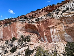
Sandsational! by FOTG The Mansard Trail is a popular trail just outside of Kanab Utah that ends at an alcove containing a unique array of petroglyphs. The site is well-known locally and promoted by various tourist outlets. The trail begins on the periphery of a neighborhood just outside town and is easy to reach. The sometimes sandy trail is well signed and offers some excellent hiking, big views and terrific scenery along with its prehistoric attraction. There are no amenities at the trailhead. Hike The wide trail heads north from the trailhead and then quickly narrows into a sandy single track that begins to steadily climb along an uphill grade that pretty much stays the same for most of the hike to the alcove. Several switchbacks along the way help to ease the steady ascent. At approximately nine-tenths of a mile one will encounter a small class 3/4 obstacle in the trail. The obstacle is marked by a carsonite sign post stating Mansard Trail with an arrow pointing to the direction of the trail and the small "climb." The obstacle amounts to a 6-8 foot semi-vertical section with a few nice holds and ledges to stand on, making it a rather mellow endeavor. Use caution with dogs here, in particular on the descent. A harnessed dog would make for easier handling here. For reference, the author's athletic well-broken trail dog bounded up the obstacle but was secured and passed down to a second person for the descent.
The site is well monitored and there is a register as well to sign in. The petroglyphs are located in an ascetic alcove with some excellent views and serves as a worthy destination in itself. The petroglyphs are unique in the fact that they sit on a nearly horizontal face. Therefore, they are not conducive to being seen up close. Bring a good camera and stay behind the wood beam barriers. Despite the somewhat limited viewing opportunity, the petroglyphs are still visually stunning and thought-provoking. Take note of the long deeply carved troughs in the sandstone that are most likely related to a phenomenon of, "cup and channel petroglyphs" that occur across this region of the Southwest. Some archaeologists have speculated that these petroglyphs are related to water ceremonies. After taking in your surroundings and reflecting on those who came before you, return the way you came. Check out the Official Route and Triplog. Leave No Trace and +Add a Triplog after your hike to support this local community. One-Way Notice This hike is listed as One-Way. When hiking several trails on a single "hike", log it with a generic name that describes the hike. Then link the trails traveled, check out the example. | ||||||||||||||||||||||||||||||||||||||||||||||||||||||||||||||||||||||||||||||||||||||||


