Route Editor

| Guide | ♦ | 2 Triplogs | 0 Topics |
details | drive | permit | forecast | route |
stats |
photos | triplogs | topics | location |
| 33 | 2 | 0 |
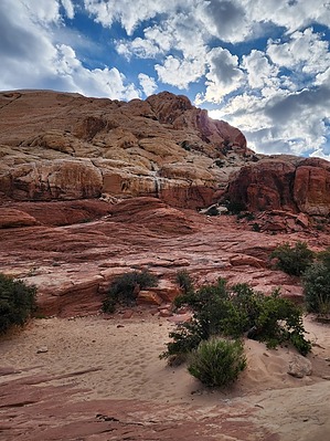
Red Rock fun near Vegas! by Vashti  This hike would be very hot in summer. There is no shade along the trail. Full sun exposure the entire time. Overview This hike offers an escape from the Vegas city sprawl. It is a popular hike, so it is best done early before throngs of people show up. The hike includes some fabulous red rocks along with fantastic views!
Be sure to visit the Red Rock Canyon website to see if entry reservations are required before you go. The Calico Tanks Trail is within the Red Rock Canyon Conservancy. The Trailhead is off the main scenic drive, at the third stop after the visitor center. The Trailhead has restrooms but no water. Dogs are allowed on a leash, but mountain biking is it allowed. Hike Calico Tanks Trail shares a trailhead with the Turtle Peak Trail. Both trails are well marked with labeled trail markers, and each trail has an informational sign and map at the trailhead. The two trails start together, but shortly thereafter, the Calico Tanks Trail heads off to the left. The start of the trail is quite sandy with some scrub vegetation before heading into a canyon and gradually going up. The trail turns from sand to slick-rock with some small climbs, but nothing substantial. There are marvelous red rock views all around. The trail continues to be marked, and in some sections there are created stone steps. The trail itself terminates at a saddle which serves as a lookout to Vegas valley below. Just before the final ascent to the saddle, there is a marshy section which had a few inches of water. We were lucky enough to have the view to ourselves for a bit, given our early-ish start, but before too long, many people started arriving. After you finish enjoying the view, turn around and head back the way you came. You can spend some time exploring the area around the lookout, but this is where the trail ends. Water Sources There was water before the lookout in mid-April, but I doubt the water will last long in the heat of the summer. Camping Camping is allowed in the Red Rock Canyon Campground, 2 miles east of the visitor center. The visitor center is at the start of the 13-mile scenic drive through Red Rock Canyon. Note The scenic drive is one-way, so if you want to visit the visitor center, you need to do it first before proceeding to the Calico Tanks Trailhead. Otherwise, you would need another timed-entry reservation to get back into the area to see the visitor center, which is just past the manned fee gates. Synopsis This is a great short hike to do with friends who are up for an adventure, but are possibly not avid hikers. It is short and sweet with great views! Gate Policy: If a gate is closed upon arrival, leave it closed after you go through. If it is open, leave it open. Leaving a closed gate open may put cattle in danger. Closing an open gate may cut them off from water. Please be respectful, leave gates as found. The exception is signage on the gate directing you otherwise. Check out the Official Route and Triplogs. Leave No Trace and +Add a Triplog after your hike to support this local community. | ||||||||||||||||||||||||||||||||||||||||||||||||||||||||||||||||||||||||||||||||||