Route Editor

| Guide | ♦ | 1 Triplog | 0 Topics |
details | drive | permit | forecast | route |
stats |
photos | triplog | topics | location |
| 6 | 1 | 0 |
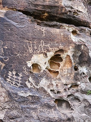
Short stroll to a Petroglyph wall by Vashti  This trail is fully exposed to the sun and would be very hot in the summer. There is no shade of any kind. Overview This is a quick walk to a nearby Petroglyph wall. There is plenty of parking at the trailhead along with a restroom and trail sign with map.
The trailhead is located just past halfway through the 13-mile one-way scenic drive of Red Rock Canyon. Exit the parking area and follow the well-worn trail to the petroglyph wall. There is a fence in front of the wall and an informational sign. Enjoy the petroglyphs and return the same way you came. Water Sources No water on the trail. Camping Backcountry camping is allowed above 5000 feet in Red Rock Canyon. A permit is required, which is available through recreation.gov. Camping is not allowed near the petroglyph wall area, as the elevation is too low. The established Red Rock Canyon Campground is 2 miles east of the Red Rock visitor center. Note Timed entry reservations and a fee are required to enter Red Rock Canyon during peak season (October 1 to May 31) and times (8a to 5p). See the BLM Red Rock Canyon National Conservation Area page for more detailed information. Synopsis This is a worthy stop while making the scenic drive within Red Rock Canyon. Check out the Official Route and Triplog. Leave No Trace and +Add a Triplog after your hike to support this local community. | |||||||||||||||||||||||||||||||||||||||||||||||||||||||||||||||||||||||||||||||||||||