Route Editor

| Guide | ♦ | 8 Triplogs | 0 Topics |
details | drive | no permit | forecast | map |
stats |
photos | triplogs | topics | location |
| 44 | 8 | 0 |
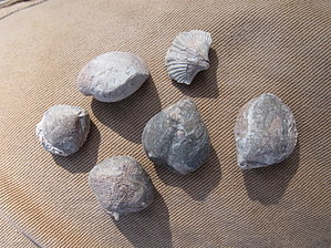
Brachiopods by the million by hippiepunkpirate   Introduction IntroductionThis roadside paleontology site is a great place for a shortstop (or all-day hunt) for fossils of the Naco Formation, a Pennsylvanian shale/limestone deposited 300 million years ago. It barely constitutes a hike, as the rock outcrops are within 100 yards of the parking lot. I visited this site in October 2009 on a paleontology field trip for my Geology 225 class at NAU. I did not consider writing this description until I got home, so at the time of this writing, I only have photos of the specimens I collected, but none showing the layout of the site. Hopefully, additional photos will be posted in the future to supplement my written description. During my trip here, I had the best luck finding small brachiopod fossils as well as slabs containing fenestrate bryozoans. I also snagged a bi-valve that one of the grad students found. Other people in my class found spiriferoids, crinoids, and even a good-sized gastropod.
From the parking lot, the collecting site is direct to the south, on the other side of a wire fence. After passing through the gate in the fence, you will notice an exposed rock outcrop to your right approximately 25-30 feet tall. This is the main collecting area that most focus on, and requires some digging and scrambling upslope. This seems to be the area where most of the larger brachiopods (including spiriferoids) can be found. Although I did not find crinoids at this locality, classmates of mine reported finding crinoids at the southern end of the outcrop. I did find a couple of nice slabs at the southern end, one containing at least two small brachiopods and the other containing fenestrate bryozoans. Below the outcrop face, there are some piles of rubble, some being of Naco material and some from outside this locality. The Naco material generally has a purple hue to it while the outside material has a tan/buff color. Ignore the tan/buff material, you will be wasting your time. In the pile of Naco rubble, I found some small bryozoan fossils, so it is worth looking through. My favorite area of the site was just over the top of the big rock outcrop along an old jeep track running to the southwest. To the right of the jeep track is a small hill that is a hotbed for little brachiopods. You can sit at just about any spot on the slope and pick up dozens of brachiopods without moving. This is where my bi-valve specimen came from, as well as some nice bryozoan slabs. Crinoid material and a rare gastropod can also be found out here. My paleo professor encouraged us to collect as much material as we wanted as the outcrops are constantly weathering out with new material being unearthed continually. NAU has been collecting at this site for about 30 years, and we still discover new species and more complete specimens every year. Keeping what you find is not an issue if you choose to do so. Gate Policy: If a gate is closed upon arrival, leave it closed after you go through. If it is open, leave it open. Leaving a closed gate open may put cattle in danger. Closing an open gate may cut them off from water. Please be respectful, leave gates as found. The exception is signage on the gate directing you otherwise. Check out the Triplogs. Leave No Trace and +Add a Triplog after your hike to support this local community. | |||||||||||||||||||||||||||||||||||||||||||||||||||||||||||||||||||||||||||||||||||