Route Editor

| Guide | ♦ | 3 Triplogs | 0 Topics |
details | drive | permit | forecast | route |
stats |
photos | triplogs | topics | location |
| 13 | 3 | 0 |
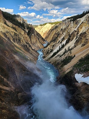
Raging River with Canyon Views by Vashti The North Rim Trail of the Yellowstone River offers many beautiful views of the river and canyon, as well as a couple of spur trails and overlooks to get closer to the waterfalls. Some of the trail is paved, some is an old road, and even parts that are not paved are so flat and wide they seem more like a sidewalk than a trail. There are some bouts of solitude possible on this trail, but many overlooks have large parking lots next to them, so there are quite a bit of people along the trails length.
The trail can be done from the top or bottom. This guide begins at the lower trail end at the Wapiti Lake Trailhead. There is a North Rim Trailhead that shows on Google Maps, but in real life, there is no Trailhead there and no parking available. The North Rim Trailhead is where the North Rim Trail starts. Park at Wapiti Lake Trailhead, and then cross the Yellowstone River on the Chittenden Bridge. There is no separate sidewalk, so you share the road with cars. After crossing the bridge and the road, the North Rim Trail begins. This area of the trail is a former road, and now it has degrading pavement that is still wide. This road is still used for service vehicles, as there is some machinery between the road and the river that can be seen. This area is densely forested. Nothing much to see in this area of the trail except for trees. You do cross a crumbling automobile bridge (the Canyon bridge). You can see why the road was closed and cars aren't allowed this way any longer. At 0.6 miles, the trail reaches the Upper Falls overlook. There is an upper section even with the trail, and then there is a secondary section down a few flights of stairs. It's worth it to go down the stairs and get a good view of the upper falls. There are lots and lots of people in this area, as there is an overlook parking lot and restrooms nearby. The trail continues along the parking lot and sidewalk, and then heads off into the forest again. The next spur is a very short trail to the overlook for Crystal Falls. After returning to the trail and continuing, the trail passes the creek just upstream of Crystal Falls. Continuing, the next major spur is at 1.5 miles in and goes down to the lower falls, officially named Brink of the Lower Falls. The trail isn't long (just shy of half a mile), but it loses a bit of elevation (230 ft) in the form of switchbacks. It is a worthwhile viewpoint, though, with superb views. There is a big parking lot at the start of this Lower Falls spur, so accordingly, a bijillion people are going up and down the trail and at the viewpoint itself. Despite this, it is still worth doing to see the sheer amount of water and power of the lower falls. It is really something to see. And the views down the Canyon are breathtaking. After oohing and aahing at the viewpoint, head back up and continue. The trail from this point roughly parallels North Rim Drive, which takes cars to Inspiration Point. You cannot always see the road from the trail, but sometimes you can. Everything is in the same area. From the Brink of the Lower Falls, the trail continues along the massive parking lot and passes restrooms before passing some lookout areas, and then it is back onto more of a wilderness trail. Much fewer people in this area, which is nice. The trail is also very close to the canyon rim edge in this area, so be mindful and watch your step. Where the trees allow, there are some great views of the canyon and river in this section. 0.75 miles past the junction with the Brink of the Lower Falls trail is the trail down to Red Rock Point. This spur is many wooden stairs along with switchbacks. The trail loses 265 ft in 0.5 mile. It is a nice view from the observation deck at the bottom. There is one section of the boardwalk that I was very thankful for. With exposure on either side, I would have hated to see what the spur trail looked like before the boardwalk! Given a parking lot at the spur junction, again, there are many people, but not everyone wants to walk down. I definitely thought it was worth it! After coming back up the spur trail, there are two further lookouts if continuing. Almost immediately is Lookout Point, and a mile away or so is Inspiration Point. Our original plan was to go all the way to Inspiration Point, but this was our second hike of the day, and we were losing daylight. We opted to turn around after coming up from Red Rock Point. The North Rim trail is out and back, so wherever you decide to turn around, you simply retrace your steps back to the trailhead. This trail is not remote or offering much solitude, but there are some beautiful views and scenery! Check out the Official Route and Triplogs. Leave No Trace and +Add a Triplog after your hike to support this local community. | |||||||||||||||||||||||||||||||||||||||||||||||||||||||||||||||||||||||||||||||||||||||||